Zhongying geodata
Zhongying (Hubei) is a seat of a fourth-order administrative division; located in China in Asia/Shanghai (GMT+8) time zone. In our database, there are 1268 cities with bigger population. Compared to other cities in China, 54.3% of cities are located further ↑North; 71.4% of cities are located further →East and 83.9% of cities have lower elevation than Zhongying. Note1


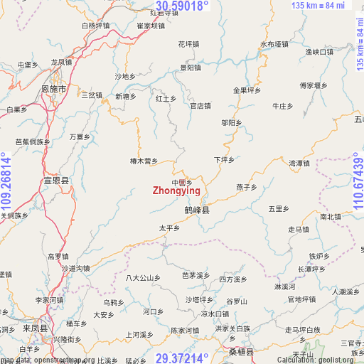
Zhongying GPS coordinates[2]
29° 58' 58.908" North, 109° 58' 16.536" East
| Map corner | latitude | longitude |
|---|---|---|
| Upper-left | 30.59018°, | 109.26814° |
| Center: | 29.98303°, | 109.97126° |
| Lower-right: | 29.37214°, | 110.67439° |
| Map W x H: | 135.4×135.4 km | = 84.1×84.1mi |
| max Lat: | 53.31946° ⇑54.3% North |
| Zhongying: | 29.98303° |
| min Lat: | ⇓45.7% South 18.22056° |
| min Long | Zhongying | max Long |
| 75.07348° | 109.97126° | 134.28917° |
| W 28.6%⇐ | ⇒71.4% E |
Elevation
Elevation of Zhongying is 912 m = 2992 ft, and this is 427.2 m = 1402 ft above average elevation for this country.
| Max E: |
5622 m = 18445 ft | 16.1% |
| Zhongying | 912 m 2992 ft | |
| Avg. | 484.8 m = 1591 ft | |
Min E: |
-3 m = -10 ft | 83.9% |
See also: China elevation on elevation.city.
Geographical zone
Zhongying is located in North temperate zone (between Tropic of Cancer and the Arctic Circle). Distance of this Northern Tropic circle is 727.9 km =452.3 mi to South.| Distance of | km | miles | from Zhongying |
|---|---|---|---|
| North Pole | 6673.3 | 4146.6 | to North |
| Arctic Circle | 4067.4 | 2527.4 | to North |
| Tropic Cancer | 727.9 | 452.3 | to South |
| Equator | 3333.8 | 2071.5 | to South |


Nearby cities:
15 places around Zhongying: (largest is in red/bold)
• Bamaoxi
34.8 km =21.6 mi,  171°
171°
• Chunmuying
16.3 km =10.1 mi,  299°
299°
• Guandian
29.4 km =18.3 mi,  13°
13°
• Hongtu
31.8 km =19.8 mi,  348°
348°
• Kuzhuping
38.9 km =24.2 mi,  163°
163°
• Longtanping
38.4 km =23.9 mi,  152°
152°
• Rongmei
11.3 km =7 mi, 152°
• Shadiping
38.2 km =23.7 mi,  202°
202°
• Shangcunba
33.3 km =20.7 mi,  359°
359°
• Taiping
17.4 km =10.8 mi, 195°
• Wangjiaping
31.6 km =19.6 mi,  190°
190°
• Wuli
37.3 km =23.2 mi,  104°
104°
• Wuyang
28.8 km =17.9 mi,  39°
39°
• Xintang
38.6 km =24 mi,  326°
326°
• Yanzi
24 km =14.9 mi,  93°
93°
Sources, notices
• [Note1] Compared only with cities in China existing in our database
• [Src1] Map data: © OpenStreetMap contributors (CC-BY-SA)
• [Src2] Other city data from geonames.org with taken over terms of usage.
• [Src3] Geographical zone / Annual Mean Temperature by Robert A. Rohde @ Wikipedia
