Hehua geodata
Hehua (Hubei) is a seat of a fourth-order administrative division; located in China in Asia/Shanghai (GMT+8) time zone. In our database, there are 1268 cities with bigger population. Compared to other cities in China, 56.2% of cities are located further ↓South; 65.4% of cities are located further →East and 75.7% of cities have lower elevation than Hehua. Note1


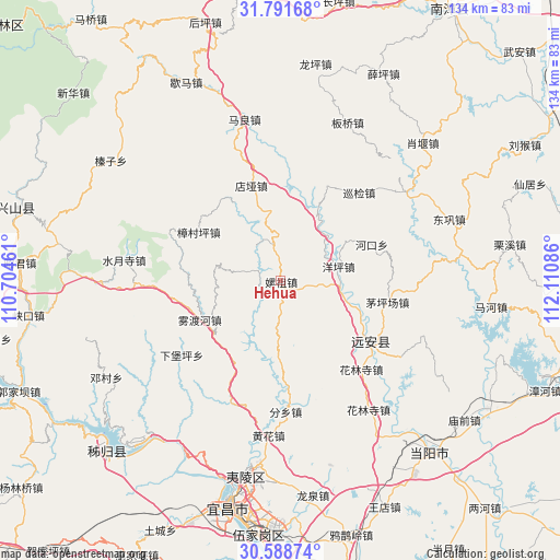
Hehua GPS coordinates[2]
31° 11' 31.632" North, 111° 24' 27.828" East
| Map corner | latitude | longitude |
|---|---|---|
| Upper-left | 31.79168°, | 110.70461° |
| Center: | 31.19212°, | 111.40773° |
| Lower-right: | 30.58874°, | 112.11086° |
| Map W x H: | 133.8×133.8 km | = 83.1×83.1mi |
| max Lat: | 53.31946° ⇑43.8% North |
| Hehua: | 31.19212° |
| min Lat: | ⇓56.2% South 18.22056° |
| min Long | Hehua | max Long |
| 75.07348° | 111.40773° | 134.28917° |
| W 34.6%⇐ | ⇒65.4% E |
Elevation
Elevation of Hehua is 539 m = 1768 ft, and this is 54.2 m = 178 ft above average elevation for this country.
| Max E: |
5622 m = 18445 ft | 24.3% |
| Hehua | 539 m 1768 ft | |
| Avg. | 484.8 m = 1591 ft | |
Min E: |
-3 m = -10 ft | 75.7% |
See also: China elevation on elevation.city.
Geographical zone
Hehua is located in North temperate zone (between Tropic of Cancer and the Arctic Circle). Distance of this Northern Tropic circle is 862.3 km =535.8 mi to South.| Distance of | km | miles | from Hehua |
|---|---|---|---|
| North Pole | 6538.8 | 4063 | to North |
| Arctic Circle | 3932.9 | 2443.8 | to North |
| Tropic Cancer | 862.3 | 535.8 | to South |
| Equator | 3468.2 | 2155 | to South |


Nearby cities:
15 places around Hehua: (largest is in red/bold)
• Dianya
24 km =14.9 mi,  342°
342°
• Fenxiang
31.2 km =19.4 mi,  178°
178°
• Hekou
23.5 km =14.6 mi,  68°
68°
• Hualinsi
28.4 km =17.6 mi,  137°
137°
• Huanghua
37.1 km =23.1 mi, 184°
• Jiuxian
20.6 km =12.8 mi,  112°
112°
• Maliang
39.5 km =24.5 mi,  347°
347°
• Maopingchang
26 km =16.2 mi,  102°
102°
• Mingfeng
26.7 km =16.6 mi,  122°
122°
• Shuiyuesi
37.8 km =23.5 mi,  277°
277°
• Wuduhe
21.3 km =13.2 mi,  244°
244°
• Xiabaoping
29.5 km =18.3 mi,  233°
233°
• Xunjian
29 km =18 mi,  41°
41°
• Yangping
14.3 km =8.9 mi,  75°
75°
• Zhangcunping
22.6 km =14 mi,  301°
301°
Sources, notices
• [Note1] Compared only with cities in China existing in our database
• [Src1] Map data: © OpenStreetMap contributors (CC-BY-SA)
• [Src2] Other city data from geonames.org with taken over terms of usage.
• [Src3] Geographical zone / Annual Mean Temperature by Robert A. Rohde @ Wikipedia
