Yangping geodata
Yangping (Hubei) is a seat of a fourth-order administrative division; located in China in Asia/Shanghai (GMT+8) time zone. In our database, there are 1268 cities with bigger population. Compared to other cities in China, 56.5% of cities are located further ↓South; 64.8% of cities are located further →East and 51.3% of cities have higher elevation than Yangping. Note1


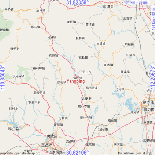
Yangping GPS coordinates[2]
31° 13' 27.264" North, 111° 33' 12.96" East
| Map corner | latitude | longitude |
|---|---|---|
| Upper-left | 31.82359°, | 110.85048° |
| Center: | 31.22424°, | 111.5536° |
| Lower-right: | 30.62106°, | 112.25673° |
| Map W x H: | 133.7×133.7 km | = 83.1×83.1mi |
| max Lat: | 53.31946° ⇑43.5% North |
| Yangping: | 31.22424° |
| min Lat: | ⇓56.5% South 18.22056° |
| min Long | Yangping | max Long |
| 75.07348° | 111.5536° | 134.28917° |
| W 35.2%⇐ | ⇒64.8% E |
Elevation
Elevation of Yangping is 154 m = 505 ft, and this is 330.8 m = 1085 ft below average elevation for this country.
| Max E: |
5622 m = 18445 ft | 51.3% |
| Avg. | 484.8 m = 1591 ft | |
| Yangping | 154 m = 505 ft | |
Min E: |
-3 m = -10 ft | 48.7% |
See also: China elevation on elevation.city.
Geographical zone
Yangping is located in North temperate zone (between Tropic of Cancer and the Arctic Circle). Distance of this Northern Tropic circle is 865.9 km =538 mi to South.| Distance of | km | miles | from Yangping |
|---|---|---|---|
| North Pole | 6535.3 | 4060.8 | to North |
| Arctic Circle | 3929.4 | 2441.6 | to North |
| Tropic Cancer | 865.9 | 538 | to South |
| Equator | 3471.8 | 2157.3 | to South |


Nearby cities:
15 places around Yangping: (largest is in red/bold)
• Banqiao
34.1 km =21.2 mi,  5°
5°
• Dianya
28.5 km =17.7 mi,  312°
312°
• Donggong
28.7 km =17.8 mi,  66°
66°
• Fenxiang
37 km =23 mi,  200°
200°
• Hehua
14.3 km =8.9 mi,  255°
255°
• Hekou
9.5 km =5.9 mi,  57°
57°
• Hualinsi
25.1 km =15.6 mi,  167°
167°
• Jiuxian
12.6 km =7.8 mi,  156°
156°
• Mahe
37.5 km =23.3 mi,  104°
104°
• Maopingchang
14.7 km =9.1 mi,  128°
128°
• Mingfeng
20 km =12.4 mi,  154°
154°
• Wuduhe
35.5 km =22.1 mi,  248°
248°
• Xiaoyan
35.6 km =22.1 mi,  34°
34°
• Xunjian
18.8 km =11.7 mi,  17°
17°
• Zhangcunping
34.1 km =21.2 mi,  283°
283°
Sources, notices
• [Note1] Compared only with cities in China existing in our database
• [Src1] Map data: © OpenStreetMap contributors (CC-BY-SA)
• [Src2] Other city data from geonames.org with taken over terms of usage.
• [Src3] Geographical zone / Annual Mean Temperature by Robert A. Rohde @ Wikipedia
