Hekou geodata
Hekou (Hubei) is a seat of a fourth-order administrative division; located in China in Asia/Shanghai (GMT+8) time zone. In our database, there are 1268 cities with bigger population. Compared to other cities in China, 56.8% of cities are located further ↓South; 64.3% of cities are located further →East and 61.7% of cities have lower elevation than Hekou. Note1


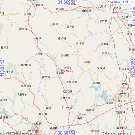
Hekou GPS coordinates[2]
31° 16' 13.908" North, 111° 38' 14.712" East
| Map corner | latitude | longitude |
|---|---|---|
| Upper-left | 31.86959°, | 110.9343° |
| Center: | 31.27053°, | 111.63742° |
| Lower-right: | 30.66764°, | 112.34055° |
| Map W x H: | 133.6×133.6 km | = 83×83mi |
| max Lat: | 53.31946° ⇑43.2% North |
| Hekou: | 31.27053° |
| min Lat: | ⇓56.8% South 18.22056° |
| min Long | Hekou | max Long |
| 75.07348° | 111.63742° | 134.28917° |
| W 35.7%⇐ | ⇒64.3% E |
Elevation
Elevation of Hekou is 279 m = 915 ft, and this is 205.8 m = 675 ft below average elevation for this country.
| Max E: |
5622 m = 18445 ft | 38.3% |
| Avg. | 484.8 m = 1591 ft | |
| Hekou | 279 m = 915 ft | |
Min E: |
-3 m = -10 ft | 61.7% |
See also: China elevation on elevation.city.
Geographical zone
Hekou is located in North temperate zone (between Tropic of Cancer and the Arctic Circle). Distance of this Northern Tropic circle is 871 km =541.2 mi to South.| Distance of | km | miles | from Hekou |
|---|---|---|---|
| North Pole | 6530.1 | 4057.6 | to North |
| Arctic Circle | 3924.2 | 2438.4 | to North |
| Tropic Cancer | 871 | 541.2 | to South |
| Equator | 3477 | 2160.5 | to South |


Nearby cities:
15 places around Hekou: (largest is in red/bold)
• Banqiao
29.2 km =18.1 mi,  350°
350°
• Dianya
32.2 km =20 mi,  296°
296°
• Donggong
19.4 km =12.1 mi,  71°
71°
• Hehua
23.5 km =14.6 mi,  248°
248°
• Hualinsi
29.8 km =18.5 mi,  185°
185°
• Jiuxian
16.9 km =10.5 mi, 189°
• Lixi
32.9 km =20.4 mi,  89°
89°
• Mahe
31.8 km =19.8 mi,  116°
116°
• Maopingchang
14.7 km =9.1 mi,  166°
166°
• Mingfeng
23.2 km =14.4 mi,  178°
178°
• Xianju
40.3 km =25 mi, 69°
• Xiaoyan
27.1 km =16.8 mi,  26°
26°
• Xueping
40.8 km =25.4 mi,  3°
3°
• Xunjian
13.1 km =8.1 mi, 349°
• Yangping
9.5 km =5.9 mi,  237°
237°
Sources, notices
• [Note1] Compared only with cities in China existing in our database
• [Src1] Map data: © OpenStreetMap contributors (CC-BY-SA)
• [Src2] Other city data from geonames.org with taken over terms of usage.
• [Src3] Geographical zone / Annual Mean Temperature by Robert A. Rohde @ Wikipedia
