Maopingchang geodata
Maopingchang (Hubei) is a seat of a fourth-order administrative division; located in China in Asia/Shanghai (GMT+8) time zone. In our database, there are 1268 cities with bigger population. Compared to other cities in China, 55.9% of cities are located further ↓South; 64.1% of cities are located further →East and 51.5% of cities have lower elevation than Maopingchang. Note1


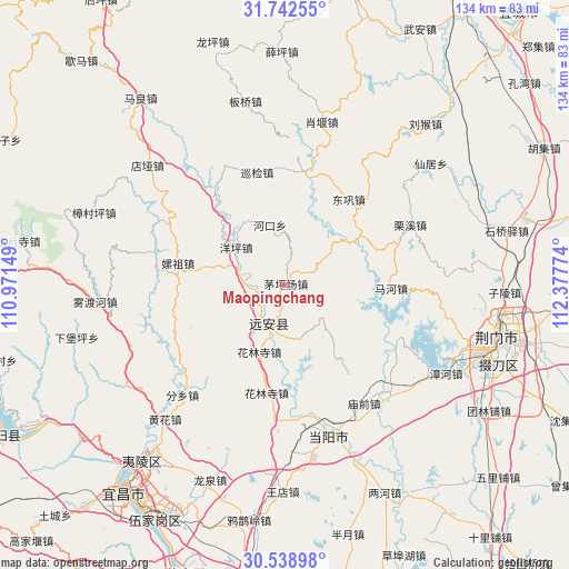
Maopingchang GPS coordinates[2]
31° 8' 33.612" North, 111° 40' 28.596" East
| Map corner | latitude | longitude |
|---|---|---|
| Upper-left | 31.74255°, | 110.97149° |
| Center: | 31.14267°, | 111.67461° |
| Lower-right: | 30.53898°, | 112.37774° |
| Map W x H: | 133.8×133.8 km | = 83.1×83.1mi |
| max Lat: | 53.31946° ⇑44.1% North |
| Maopingchang: | 31.14267° |
| min Lat: | ⇓55.9% South 18.22056° |
| min Long | Maopingchang | max Long |
| 75.07348° | 111.67461° | 134.28917° |
| W 35.9%⇐ | ⇒64.1% E |
Elevation
Elevation of Maopingchang is 177 m = 581 ft, and this is 307.8 m = 1010 ft below average elevation for this country.
| Max E: |
5622 m = 18445 ft | 48.5% |
| Avg. | 484.8 m = 1591 ft | |
| Maopingchang | 177 m = 581 ft | |
Min E: |
-3 m = -10 ft | 51.5% |
See also: China elevation on elevation.city.
Geographical zone
Maopingchang is located in North temperate zone (between Tropic of Cancer and the Arctic Circle). Distance of this Northern Tropic circle is 856.8 km =532.4 mi to South.| Distance of | km | miles | from Maopingchang |
|---|---|---|---|
| North Pole | 6544.3 | 4066.4 | to North |
| Arctic Circle | 3938.4 | 2447.2 | to North |
| Tropic Cancer | 856.8 | 532.4 | to South |
| Equator | 3462.7 | 2151.6 | to South |


Nearby cities:
15 places around Maopingchang: (largest is in red/bold)
• Baling
35.2 km =21.9 mi,  161°
161°
• Donggong
25.2 km =15.7 mi,  36°
36°
• Fenxiang
35.4 km =22 mi,  223°
223°
• Hehua
26 km =16.2 mi,  282°
282°
• Hekou
14.7 km =9.1 mi,  346°
346°
• Hualinsi
16.6 km =10.3 mi,  201°
201°
• Jiuxian
6.8 km =4.2 mi,  249°
249°
• Lixi
32.6 km =20.3 mi,  64°
64°
• Mahe
24.8 km =15.4 mi,  90°
90°
• Miaoqian
33.6 km =20.9 mi,  146°
146°
• Mingfeng
9.5 km =5.9 mi, 198°
• Xiaoyan
39.4 km =24.5 mi,  12°
12°
• Xunjian
27.7 km =17.2 mi, 347°
• Yangping
14.7 km =9.1 mi,  308°
308°
• Yuquan
36.1 km =22.4 mi, 164°
Sources, notices
• [Note1] Compared only with cities in China existing in our database
• [Src1] Map data: © OpenStreetMap contributors (CC-BY-SA)
• [Src2] Other city data from geonames.org with taken over terms of usage.
• [Src3] Geographical zone / Annual Mean Temperature by Robert A. Rohde @ Wikipedia
