Jiuxian geodata
Jiuxian (Hubei) is a seat of a fourth-order administrative division; located in China in Asia/Shanghai (GMT+8) time zone. In our database, there are 1268 cities with bigger population. Compared to other cities in China, 55.7% of cities are located further ↓South; 64.5% of cities are located further →East and 56% of cities have higher elevation than Jiuxian. Note1


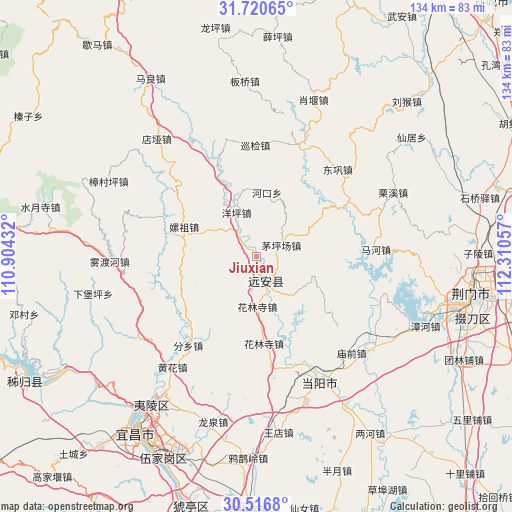
Jiuxian GPS coordinates[2]
31° 7' 14.268" North, 111° 36' 26.784" East
| Map corner | latitude | longitude |
|---|---|---|
| Upper-left | 31.72065°, | 110.90432° |
| Center: | 31.12063°, | 111.60744° |
| Lower-right: | 30.5168°, | 112.31057° |
| Map W x H: | 133.9×133.9 km | = 83.2×83.2mi |
| max Lat: | 53.31946° ⇑44.3% North |
| Jiuxian: | 31.12063° |
| min Lat: | ⇓55.7% South 18.22056° |
| min Long | Jiuxian | max Long |
| 75.07348° | 111.60744° | 134.28917° |
| W 35.5%⇐ | ⇒64.5% E |
Elevation
Elevation of Jiuxian is 124 m = 407 ft, and this is 360.8 m = 1184 ft below average elevation for this country.
| Max E: |
5622 m = 18445 ft | 56% |
| Avg. | 484.8 m = 1591 ft | |
| Jiuxian | 124 m = 407 ft | |
Min E: |
-3 m = -10 ft | 44% |
See also: China elevation on elevation.city.
Geographical zone
Jiuxian is located in North temperate zone (between Tropic of Cancer and the Arctic Circle). Distance of this Northern Tropic circle is 854.4 km =530.9 mi to South.| Distance of | km | miles | from Jiuxian |
|---|---|---|---|
| North Pole | 6546.8 | 4068 | to North |
| Arctic Circle | 3940.9 | 2448.8 | to North |
| Tropic Cancer | 854.4 | 530.9 | to South |
| Equator | 3460.3 | 2150.1 | to South |


Nearby cities:
15 places around Jiuxian: (largest is in red/bold)
• Baling
35.6 km =22.1 mi,  150°
150°
• Donggong
31.2 km =19.4 mi,  43°
43°
• Fenxiang
29.3 km =18.2 mi,  217°
217°
• Hehua
20.6 km =12.8 mi,  292°
292°
• Hekou
16.9 km =10.5 mi,  9°
9°
• Hualinsi
13 km =8.1 mi,  178°
178°
• Huanghua
36.3 km =22.6 mi, 216°
• Mahe
31.3 km =19.4 mi,  85°
85°
• Maopingchang
6.8 km =4.2 mi,  69°
69°
• Miaoqian
35.8 km =22.2 mi,  135°
135°
• Mingfeng
7.4 km =4.6 mi, 152°
• Wuduhe
38.3 km =23.8 mi,  268°
268°
• Xunjian
29.5 km =18.3 mi,  0°
0°
• Yangping
12.6 km =7.8 mi,  336°
336°
• Yuquan
36 km =22.4 mi, 153°
Sources, notices
• [Note1] Compared only with cities in China existing in our database
• [Src1] Map data: © OpenStreetMap contributors (CC-BY-SA)
• [Src2] Other city data from geonames.org with taken over terms of usage.
• [Src3] Geographical zone / Annual Mean Temperature by Robert A. Rohde @ Wikipedia
