Mahe geodata
Mahe (Hubei) is a seat of a fourth-order administrative division; located in China in Asia/Shanghai (GMT+8) time zone. In our database, there are 1268 cities with bigger population. Compared to other cities in China, 55.9% of cities are located further ↓South; 63% of cities are located further →East and 50.2% of cities have higher elevation than Mahe. Note1


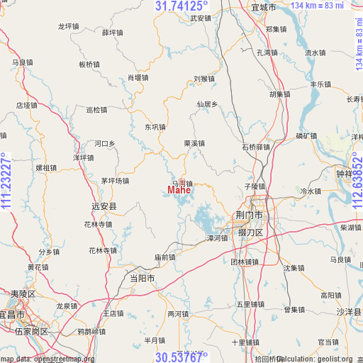
Mahe GPS coordinates[2]
31° 8' 28.932" North, 111° 56' 7.404" East
| Map corner | latitude | longitude |
|---|---|---|
| Upper-left | 31.74125°, | 111.23227° |
| Center: | 31.14137°, | 111.93539° |
| Lower-right: | 30.53767°, | 112.63852° |
| Map W x H: | 133.8×133.8 km | = 83.1×83.1mi |
| max Lat: | 53.31946° ⇑44.1% North |
| Mahe: | 31.14137° |
| min Lat: | ⇓55.9% South 18.22056° |
| min Long | Mahe | max Long |
| 75.07348° | 111.93539° | 134.28917° |
| W 37%⇐ | ⇒63% E |
Elevation
Elevation of Mahe is 163 m = 535 ft, and this is 321.8 m = 1056 ft below average elevation for this country.
| Max E: |
5622 m = 18445 ft | 50.2% |
| Avg. | 484.8 m = 1591 ft | |
| Mahe | 163 m = 535 ft | |
Min E: |
-3 m = -10 ft | 49.8% |
See also: China elevation on elevation.city.
Geographical zone
Mahe is located in North temperate zone (between Tropic of Cancer and the Arctic Circle). Distance of this Northern Tropic circle is 856.7 km =532.3 mi to South.| Distance of | km | miles | from Mahe |
|---|---|---|---|
| North Pole | 6544.5 | 4066.6 | to North |
| Arctic Circle | 3938.6 | 2447.3 | to North |
| Tropic Cancer | 856.7 | 532.3 | to South |
| Equator | 3462.6 | 2151.6 | to South |


Nearby cities:
15 places around Mahe: (largest is in red/bold)
• Baimiao
29.7 km =18.5 mi,  113°
113°
• Donggong
22.8 km =14.2 mi,  334°
334°
• Duodaoshi
31 km =19.3 mi,  130°
130°
• Hekou
31.8 km =19.8 mi,  296°
296°
• Jingmen
28.3 km =17.6 mi,  115°
115°
• Jiuxian
31.3 km =19.4 mi,  265°
265°
• Lixi
15.1 km =9.4 mi,  17°
17°
• Maopingchang
24.8 km =15.4 mi, 270°
• Miaoqian
28.4 km =17.6 mi,  192°
192°
• Mingfeng
29.2 km =18.1 mi,  252°
252°
• Pailou
34.4 km =21.4 mi, 106°
• Shiqiaoyi
29.9 km =18.6 mi,  64°
64°
• Xianju
30.3 km =18.8 mi, 18°
• Zhanghe
24.2 km =15 mi,  147°
147°
• Zilingpu
26.9 km =16.7 mi,  92°
92°
Sources, notices
• [Note1] Compared only with cities in China existing in our database
• [Src1] Map data: © OpenStreetMap contributors (CC-BY-SA)
• [Src2] Other city data from geonames.org with taken over terms of usage.
• [Src3] Geographical zone / Annual Mean Temperature by Robert A. Rohde @ Wikipedia
