Miaoqian geodata
Miaoqian (Hubei) is a seat of a fourth-order administrative division; located in China in Asia/Shanghai (GMT+8) time zone. In our database, there are 1268 cities with bigger population. Compared to other cities in China, 53.8% of cities are located further ↓South; 63.2% of cities are located further →East and 62.9% of cities have higher elevation than Miaoqian. Note1


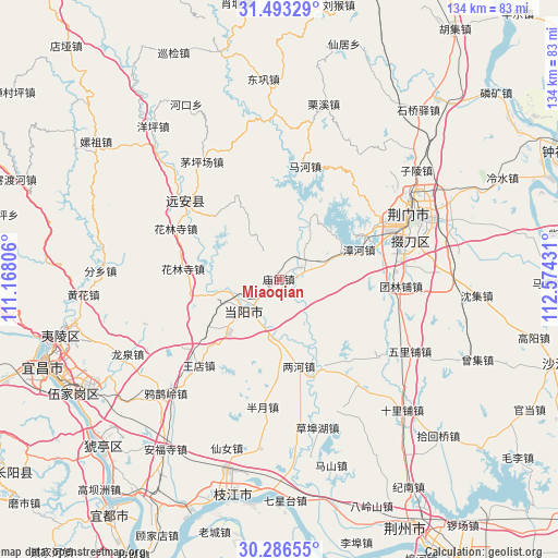
Miaoqian GPS coordinates[2]
30° 53' 30.552" North, 111° 52' 16.248" East
| Map corner | latitude | longitude |
|---|---|---|
| Upper-left | 31.49329°, | 111.16806° |
| Center: | 30.89182°, | 111.87118° |
| Lower-right: | 30.28655°, | 112.57431° |
| Map W x H: | 134.2×134.2 km | = 83.4×83.4mi |
| max Lat: | 53.31946° ⇑46.2% North |
| Miaoqian: | 30.89182° |
| min Lat: | ⇓53.8% South 18.22056° |
| min Long | Miaoqian | max Long |
| 75.07348° | 111.87118° | 134.28917° |
| W 36.8%⇐ | ⇒63.2% E |
Elevation
Elevation of Miaoqian is 83 m = 272 ft, and this is 401.8 m = 1318 ft below average elevation for this country.
| Max E: |
5622 m = 18445 ft | 62.9% |
| Avg. | 484.8 m = 1591 ft | |
| Miaoqian | 83 m = 272 ft | |
Min E: |
-3 m = -10 ft | 37.1% |
See also: China elevation on elevation.city.
Geographical zone
Miaoqian is located in North temperate zone (between Tropic of Cancer and the Arctic Circle). Distance of this Northern Tropic circle is 828.9 km =515.1 mi to South.| Distance of | km | miles | from Miaoqian |
|---|---|---|---|
| North Pole | 6572.2 | 4083.8 | to North |
| Arctic Circle | 3966.3 | 2464.5 | to North |
| Tropic Cancer | 828.9 | 515.1 | to South |
| Equator | 3434.8 | 2134.3 | to South |


Nearby cities:
15 places around Miaoqian: (largest is in red/bold)
• Baling
9.3 km =5.8 mi,  234°
234°
• Banyue
30.9 km =19.2 mi,  187°
187°
• Duodaoshi
30.9 km =19.2 mi,  75°
75°
• Herong
22.7 km =14.1 mi,  154°
154°
• Hualinsi
27.9 km =17.3 mi,  296°
296°
• Jingmen
35.5 km =22.1 mi,  63°
63°
• Jiuxian
35.8 km =22.2 mi,  315°
315°
• Lianghe
21.4 km =13.3 mi,  167°
167°
• Mahe
28.4 km =17.6 mi,  12°
12°
• Maopingchang
33.6 km =20.9 mi,  326°
326°
• Mingfeng
28.8 km =17.9 mi,  310°
310°
• Tuanlinpu
29.1 km =18.1 mi,  93°
93°
• Wangdian
28.1 km =17.5 mi,  223°
223°
• Yuquan
11.5 km =7.1 mi, 233°
• Zhanghe
20.4 km =12.7 mi,  69°
69°
Sources, notices
• [Note1] Compared only with cities in China existing in our database
• [Src1] Map data: © OpenStreetMap contributors (CC-BY-SA)
• [Src2] Other city data from geonames.org with taken over terms of usage.
• [Src3] Geographical zone / Annual Mean Temperature by Robert A. Rohde @ Wikipedia
