Machang geodata
Machang (Yunnan) is a seat of a fourth-order administrative division; located in China in Asia/Shanghai (GMT+8) time zone. In our database, there are 1268 cities with bigger population. Compared to other cities in China, 81.9% of cities are located further ↑North; 90% of cities are located further →East and 93.5% of cities have lower elevation than Machang. Note1


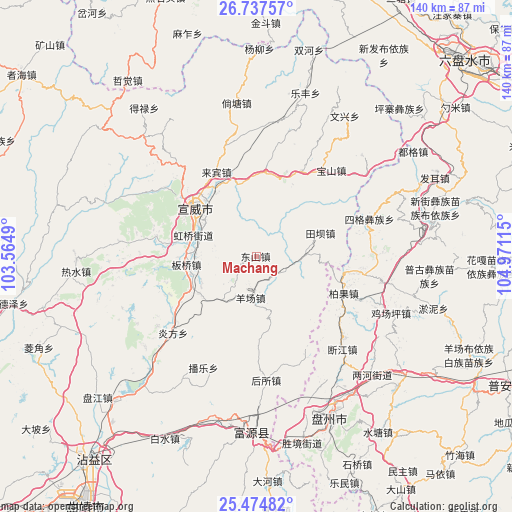
Machang GPS coordinates[2]
26° 6' 28.44" North, 104° 16' 4.872" East
| Map corner | latitude | longitude |
|---|---|---|
| Upper-left | 26.73757°, | 103.5649° |
| Center: | 26.1079°, | 104.26802° |
| Lower-right: | 25.47482°, | 104.97115° |
| Map W x H: | 140.4×140.4 km | = 87.2×87.2mi |
| max Lat: | 53.31946° ⇑81.9% North |
| Machang: | 26.1079° |
| min Lat: | ⇓18.1% South 18.22056° |
| min Long | Machang | max Long |
| 75.07348° | 104.26802° | 134.28917° |
| W 10%⇐ | ⇒90% E |
Elevation
Elevation of Machang is 1796 m = 5892 ft, and this is 1311.2 m = 4302 ft above average elevation for this country.
| Max E: |
5622 m = 18445 ft | 6.5% |
| Machang | 1796 m 5892 ft | |
| Avg. | 484.8 m = 1591 ft | |
Min E: |
-3 m = -10 ft | 93.5% |
See also: China elevation on elevation.city.
Geographical zone
Machang is located in North temperate zone (between Tropic of Cancer and the Arctic Circle). Distance of this Northern Tropic circle is 297 km =184.5 mi to South.| Distance of | km | miles | from Machang |
|---|---|---|---|
| North Pole | 7104.1 | 4414.3 | to North |
| Arctic Circle | 4498.2 | 2795.1 | to North |
| Tropic Cancer | 297 | 184.5 | to South |
| Equator | 2902.9 | 1803.8 | to South |


Nearby cities:
15 places around Machang: (largest is in red/bold)
• Chengfangqiao
58.6 km =36.4 mi,  228°
228°
• Dasongshu
69.4 km =43.1 mi,  272°
272°
• Gaojiacun
96.6 km =60 mi,  192°
192°
• Jianxincun
33.4 km =20.8 mi,  206°
206°
• Jinzhong
100.4 km =62.4 mi,  287°
287°
• Liupanshui
78.1 km =48.5 mi,  46°
46°
• Pingpo
91.4 km =56.8 mi, 214°
• Qujing
84.7 km =52.6 mi, 214°
• Shanzidi
112 km =69.6 mi,  296°
296°
• Tongquan
105.5 km =65.6 mi,  221°
221°
• Weining
82.6 km =51.3 mi,  357°
357°
• Xiaotiechang
65.8 km =40.9 mi, 287°
• Xiping
73.8 km =45.9 mi, 219°
• Zhong’an
49.2 km =30.6 mi,  184°
184°
• Zhujiacun
26.8 km =16.7 mi,  28°
28°
Sources, notices
• [Note1] Compared only with cities in China existing in our database
• [Src1] Map data: © OpenStreetMap contributors (CC-BY-SA)
• [Src2] Other city data from geonames.org with taken over terms of usage.
• [Src3] Geographical zone / Annual Mean Temperature by Robert A. Rohde @ Wikipedia
