Lianghe geodata
Lianghe (Hubei) is a seat of a fourth-order administrative division; located in China in Asia/Shanghai (GMT+8) time zone. In our database, there are 1268 cities with bigger population. Compared to other cities in China, 52.1% of cities are located further ↓South; 63.1% of cities are located further →East and 73% of cities have higher elevation than Lianghe. Note1


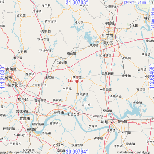
Lianghe GPS coordinates[2]
30° 42' 15.768" North, 111° 55' 17.22" East
| Map corner | latitude | longitude |
|---|---|---|
| Upper-left | 31.30703°, | 111.21833° |
| Center: | 30.70438°, | 111.92145° |
| Lower-right: | 30.09794°, | 112.62458° |
| Map W x H: | 134.4×134.4 km | = 83.5×83.5mi |
| max Lat: | 53.31946° ⇑47.9% North |
| Lianghe: | 30.70438° |
| min Lat: | ⇓52.1% South 18.22056° |
| min Long | Lianghe | max Long |
| 75.07348° | 111.92145° | 134.28917° |
| W 36.9%⇐ | ⇒63.1% E |
Elevation
Elevation of Lianghe is 42 m = 138 ft, and this is 442.8 m = 1453 ft below average elevation for this country.
| Max E: |
5622 m = 18445 ft | 73% |
| Avg. | 484.8 m = 1591 ft | |
| Lianghe | 42 m = 138 ft | |
Min E: |
-3 m = -10 ft | 27% |
See also: China elevation on elevation.city.
Geographical zone
Lianghe is located in North temperate zone (between Tropic of Cancer and the Arctic Circle). Distance of this Northern Tropic circle is 808.1 km =502.1 mi to South.| Distance of | km | miles | from Lianghe |
|---|---|---|---|
| North Pole | 6593.1 | 4096.8 | to North |
| Arctic Circle | 3987.2 | 2477.5 | to North |
| Tropic Cancer | 808.1 | 502.1 | to South |
| Equator | 3414 | 2121.4 | to South |


Nearby cities:
15 places around Lianghe: (largest is in red/bold)
• Baling
19.7 km =12.2 mi,  321°
321°
• Banyue
13.2 km =8.2 mi,  222°
222°
• Chuandian
19.3 km =12 mi,  131°
131°
• Herong
4.9 km =3 mi,  86°
86°
• Jishan
30.6 km =19 mi, 126°
• Miaoqian
21.4 km =13.3 mi,  347°
347°
• Qixingtai
32.5 km =20.2 mi,  185°
185°
• Shilipu
27 km =16.8 mi,  113°
113°
• Tuanlinpu
31 km =19.3 mi,  51°
51°
• Wangdian
24.2 km =15 mi,  271°
271°
• Wen’an
22.1 km =13.7 mi,  205°
205°
• Wulipu
26.9 km =16.7 mi,  82°
82°
• Xiannü
26.3 km =16.3 mi, 221°
• Yuquan
19.8 km =12.3 mi,  314°
314°
• Zhanghe
31.5 km =19.6 mi,  26°
26°
Sources, notices
• [Note1] Compared only with cities in China existing in our database
• [Src1] Map data: © OpenStreetMap contributors (CC-BY-SA)
• [Src2] Other city data from geonames.org with taken over terms of usage.
• [Src3] Geographical zone / Annual Mean Temperature by Robert A. Rohde @ Wikipedia
