Tanlin geodata
Tanlin (Hubei) is a seat of a fourth-order administrative division; located in China in Asia/Shanghai (GMT+8) time zone. In our database, there are 1268 cities with bigger population. Compared to other cities in China, 50.5% of cities are located further ↓South; 59.2% of cities are located further ←West and 59.4% of cities have higher elevation than Tanlin. Note1


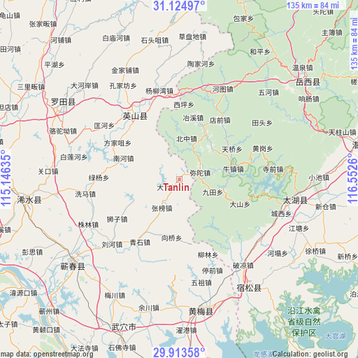
Tanlin GPS coordinates[2]
30° 31' 16.176" North, 115° 50' 58.092" East
| Map corner | latitude | longitude |
|---|---|---|
| Upper-left | 31.12497°, | 115.14635° |
| Center: | 30.52116°, | 115.84947° |
| Lower-right: | 29.91358°, | 116.5526° |
| Map W x H: | 134.7×134.7 km | = 83.7×83.7mi |
| max Lat: | 53.31946° ⇑49.5% North |
| Tanlin: | 30.52116° |
| min Lat: | ⇓50.5% South 18.22056° |
| min Long | Tanlin | max Long |
| 75.07348° | 115.84947° | 134.28917° |
| W 59.2%⇐ | ⇒40.8% E |
Elevation
Elevation of Tanlin is 102 m = 335 ft, and this is 382.8 m = 1256 ft below average elevation for this country.
| Max E: |
5622 m = 18445 ft | 59.4% |
| Avg. | 484.8 m = 1591 ft | |
| Tanlin | 102 m = 335 ft | |
Min E: |
-3 m = -10 ft | 40.6% |
See also: China elevation on elevation.city.
Geographical zone
Tanlin is located in North temperate zone (between Tropic of Cancer and the Arctic Circle). Distance of this Northern Tropic circle is 787.7 km =489.5 mi to South.| Distance of | km | miles | from Tanlin |
|---|---|---|---|
| North Pole | 6613.4 | 4109.4 | to North |
| Arctic Circle | 4007.5 | 2490.1 | to North |
| Tropic Cancer | 787.7 | 489.5 | to South |
| Equator | 3393.6 | 2108.7 | to South |


Nearby cities:
15 places around Tanlin: (largest is in red/bold)
• Datong
5.4 km =3.4 mi,  240°
240°
• Fangjiazui
27 km =16.8 mi,  300°
300°
• Hongshan
33.6 km =20.9 mi,  325°
325°
• Kuanghe
34.8 km =21.6 mi,  305°
305°
• Liuhe
35.8 km =22.2 mi,  226°
226°
• Liulin
29.8 km =18.5 mi,  159°
159°
• Lüyang
30.2 km =18.8 mi,  271°
271°
• Nanhe
22.5 km =14 mi,  290°
290°
• Qingshi
27.8 km =17.3 mi,  212°
212°
• Shizi
27.9 km =17.3 mi, 237°
• Tingqian
36.4 km =22.6 mi, 160°
• Xiangqiao
22.7 km =14.1 mi,  204°
204°
• Xima
36.4 km =22.6 mi,  261°
261°
• Yangliuwan
34.2 km =21.3 mi,  347°
347°
• Zhangbang
12.6 km =7.8 mi, 211°
Sources, notices
• [Note1] Compared only with cities in China existing in our database
• [Src1] Map data: © OpenStreetMap contributors (CC-BY-SA)
• [Src2] Other city data from geonames.org with taken over terms of usage.
• [Src3] Geographical zone / Annual Mean Temperature by Robert A. Rohde @ Wikipedia
