Guangrao geodata
Guangrao (Shandong) is a seat of a third-order administrative division; located in China in Asia/Shanghai (GMT+8) time zone. In our database, there are 1268 cities with bigger population. Compared to other cities in China, 79.7% of cities are located further ↓South; 72.9% of cities are located further ←West and 97.2% of cities have higher elevation than Guangrao. Note1


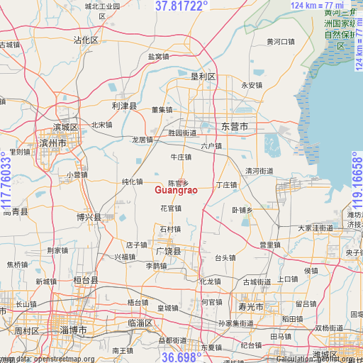
Guangrao GPS coordinates[2]
37° 15' 34.884" North, 118° 27' 48.42" East
| Map corner | latitude | longitude |
|---|---|---|
| Upper-left | 37.81722°, | 117.76033° |
| Center: | 37.25969°, | 118.46345° |
| Lower-right: | 36.698°, | 119.16658° |
| Map W x H: | 124.4×124.4 km | = 77.3×77.3mi |
| max Lat: | 53.31946° ⇑20.3% North |
| Guangrao: | 37.25969° |
| min Lat: | ⇓79.7% South 18.22056° |
| min Long | Guangrao | max Long |
| 75.07348° | 118.46345° | 134.28917° |
| W 72.9%⇐ | ⇒27.1% E |
Elevation
Elevation of Guangrao is 5 m = 16 ft, and this is 479.8 m = 1574 ft below average elevation for this country.
| Max E: |
5622 m = 18445 ft | 97.2% |
| Avg. | 484.8 m = 1591 ft | |
| Guangrao | 5 m = 16 ft | |
Min E: |
-3 m = -10 ft | 2.8% |
See also: China elevation on elevation.city.
Geographical zone
Guangrao is located in North temperate zone (between Tropic of Cancer and the Arctic Circle). Distance of this Northern Tropic circle is 1537 km =955 mi to South.| Distance of | km | miles | from Guangrao |
|---|---|---|---|
| North Pole | 5864.2 | 3643.8 | to North |
| Arctic Circle | 3258.3 | 2024.6 | to North |
| Tropic Cancer | 1537 | 955 | to South |
| Equator | 4142.9 | 2574.3 | to South |


Nearby cities:
15 places around Guangrao: (largest is in red/bold)
• Binzhou
41.3 km =25.7 mi,  286°
286°
• Guangrao
23.7 km =14.7 mi,  193°
193°
• Hanting
85.8 km =53.3 mi,  129°
129°
• Hekou
69.7 km =43.3 mi,  4°
4°
• Linqu
83 km =51.6 mi,  175°
175°
• Nanding
67.4 km =41.9 mi,  212°
212°
• Qingzhou
62.6 km =38.9 mi, 178°
• Shengli
22.7 km =14.1 mi,  6°
6°
• Shouguang
48.7 km =30.3 mi,  150°
150°
• Suozhen
46.6 km =29 mi,  223°
223°
• Weifang
83.4 km =51.8 mi,  137°
137°
• Xindian
53.5 km =33.2 mi,  196°
196°
• Yangzi
65.7 km =40.8 mi,  111°
111°
• Zhoucun
75.6 km =47 mi,  229°
229°
• Zibo
63.1 km =39.2 mi, 214°
Sources, notices
• [Note1] Compared only with cities in China existing in our database
• [Src1] Map data: © OpenStreetMap contributors (CC-BY-SA)
• [Src2] Other city data from geonames.org with taken over terms of usage.
• [Src3] Geographical zone / Annual Mean Temperature by Robert A. Rohde @ Wikipedia
