Dianyang geodata
Dianyang (Yunnan) is a seat of a third-order administrative division; located in China in Asia/Shanghai (GMT+8) time zone. In our database, there are 1268 cities with bigger population. Compared to other cities in China, 87.6% of cities are located further ↑North; 95% of cities are located further →East and 93.8% of cities have lower elevation than Dianyang. Note1


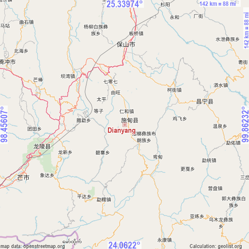
Dianyang GPS coordinates[2]
24° 42' 9.396" North, 99° 9' 33.084" East
| Map corner | latitude | longitude |
|---|---|---|
| Upper-left | 25.33974°, | 98.45607° |
| Center: | 24.70261°, | 99.15919° |
| Lower-right: | 24.0622°, | 99.86232° |
| Map W x H: | 142×142.1 km | = 88.2×88.3mi |
| max Lat: | 53.31946° ⇑87.6% North |
| Dianyang: | 24.70261° |
| min Lat: | ⇓12.4% South 18.22056° |
| min Long | Dianyang | max Long |
| 75.07348° | 99.15919° | 134.28917° |
| W 5%⇐ | ⇒95% E |
Elevation
Elevation of Dianyang is 1826 m = 5991 ft, and this is 1341.2 m = 4400 ft above average elevation for this country.
| Max E: |
5622 m = 18445 ft | 6.2% |
| Dianyang | 1826 m 5991 ft | |
| Avg. | 484.8 m = 1591 ft | |
Min E: |
-3 m = -10 ft | 93.8% |
See also: China elevation on elevation.city.
Geographical zone
Dianyang is located in North temperate zone (between Tropic of Cancer and the Arctic Circle). Distance of this Northern Tropic circle is 140.8 km =87.5 mi to South.| Distance of | km | miles | from Dianyang |
|---|---|---|---|
| North Pole | 7260.4 | 4511.4 | to North |
| Arctic Circle | 4654.5 | 2892.2 | to North |
| Tropic Cancer | 140.8 | 87.5 | to South |
| Equator | 2746.7 | 1706.7 | to South |


Nearby cities:
15 places around Dianyang: (largest is in red/bold)
• Aihua
100.3 km =62.3 mi,  108°
108°
• Dedang
77.2 km =48 mi,  173°
173°
• Fengshan
76 km =47.2 mi,  100°
100°
• Gengma
133 km =82.6 mi, 170°
• Laojie
92 km =57.2 mi,  25°
25°
• Longshan
47.4 km =29.5 mi,  256°
256°
• Nanjian
143.7 km =89.3 mi,  74°
74°
• Nansan
107.1 km =66.5 mi,  199°
199°
• Nanzhao
129 km =80.2 mi,  63°
63°
• Pingyuan
125.9 km =78.2 mi,  271°
271°
• Shangjie
135.7 km =84.3 mi,  37°
37°
• Shimen
135.3 km =84.1 mi,  11°
11°
• Tengyue
72.9 km =45.3 mi,  296°
296°
• Youdian
45.9 km =28.5 mi, 72°
• Zhedao
90.1 km =56 mi,  278°
278°
Sources, notices
• [Note1] Compared only with cities in China existing in our database
• [Src1] Map data: © OpenStreetMap contributors (CC-BY-SA)
• [Src2] Other city data from geonames.org with taken over terms of usage.
• [Src3] Geographical zone / Annual Mean Temperature by Robert A. Rohde @ Wikipedia
