Shimen geodata
Shimen (Yunnan) is a seat of a third-order administrative division; located in China in Asia/Shanghai (GMT+8) time zone. In our database, there are 1268 cities with bigger population. Compared to other cities in China, 82.8% of cities are located further ↑North; 94.9% of cities are located further →East and 94.9% of cities have lower elevation than Shimen. Note1


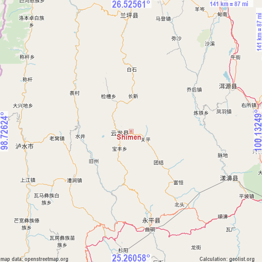
Shimen GPS coordinates[2]
25° 53' 41.244" North, 99° 25' 45.696" East
| Map corner | latitude | longitude |
|---|---|---|
| Upper-left | 26.52561°, | 98.72624° |
| Center: | 25.89479°, | 99.42936° |
| Lower-right: | 25.26058°, | 100.13249° |
| Map W x H: | 140.7×140.7 km | = 87.4×87.4mi |
| max Lat: | 53.31946° ⇑82.8% North |
| Shimen: | 25.89479° |
| min Lat: | ⇓17.2% South 18.22056° |
| min Long | Shimen | max Long |
| 75.07348° | 99.42936° | 134.28917° |
| W 5.1%⇐ | ⇒94.9% E |
Elevation
Elevation of Shimen is 2097 m = 6880 ft, and this is 1612.2 m = 5289 ft above average elevation for this country.
| Max E: |
5622 m = 18445 ft | 5.1% |
| Shimen | 2097 m 6880 ft | |
| Avg. | 484.8 m = 1591 ft | |
Min E: |
-3 m = -10 ft | 94.9% |
See also: China elevation on elevation.city.
Geographical zone
Shimen is located in North temperate zone (between Tropic of Cancer and the Arctic Circle). Distance of this Northern Tropic circle is 273.3 km =169.8 mi to South.| Distance of | km | miles | from Shimen |
|---|---|---|---|
| North Pole | 7127.8 | 4429 | to North |
| Arctic Circle | 4521.9 | 2809.8 | to North |
| Tropic Cancer | 273.3 | 169.8 | to South |
| Equator | 2879.2 | 1789.1 | to South |


Nearby cities:
15 places around Shimen: (largest is in red/bold)
• Dali
85.7 km =53.3 mi,  113°
113°
• Huangshan
130.1 km =80.8 mi,  37°
37°
• Jinding
60.5 km =37.6 mi,  1°
1°
• Jinhua
86.5 km =53.7 mi,  34°
34°
• Jinniu
115.1 km =71.5 mi,  95°
95°
• Laojie
51.2 km =31.8 mi,  165°
165°
• Luzhang
61.2 km =38 mi,  278°
278°
• Micheng
124.9 km =77.6 mi,  120°
120°
• Nanzhao
115.2 km =71.6 mi,  130°
130°
• Shangjie
60.5 km =37.6 mi, 114°
• Shangpa
123.5 km =76.7 mi,  337°
337°
• Xiangcheng
123.1 km =76.5 mi, 112°
• Youdian
119.6 km =74.3 mi, 172°
• Yuhu
60.1 km =37.3 mi,  66°
66°
• Yunhe
103.9 km =64.6 mi,  47°
47°
Sources, notices
• [Note1] Compared only with cities in China existing in our database
• [Src1] Map data: © OpenStreetMap contributors (CC-BY-SA)
• [Src2] Other city data from geonames.org with taken over terms of usage.
• [Src3] Geographical zone / Annual Mean Temperature by Robert A. Rohde @ Wikipedia
