Dedang geodata
Dedang (Yunnan) is a seat of a third-order administrative division; located in China in Asia/Shanghai (GMT+8) time zone. In our database, there are 1268 cities with bigger population. Compared to other cities in China, 90.4% of cities are located further ↑North; 95% of cities are located further →East and 92.4% of cities have lower elevation than Dedang. Note1


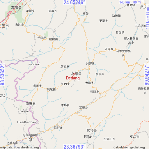
Dedang GPS coordinates[2]
24° 0' 42.48" North, 99° 14' 22.704" East
| Map corner | latitude | longitude |
|---|---|---|
| Upper-left | 24.65246°, | 98.53652° |
| Center: | 24.0118°, | 99.23964° |
| Lower-right: | 23.36793°, | 99.94277° |
| Map W x H: | 142.8×142.8 km | = 88.7×88.7mi |
| max Lat: | 53.31946° ⇑90.4% North |
| Dedang: | 24.0118° |
| min Lat: | ⇓9.6% South 18.22056° |
| min Long | Dedang | max Long |
| 75.07348° | 99.23964° | 134.28917° |
| W 5%⇐ | ⇒95% E |
Elevation
Elevation of Dedang is 1628 m = 5341 ft, and this is 1143.2 m = 3751 ft above average elevation for this country.
| Max E: |
5622 m = 18445 ft | 7.6% |
| Dedang | 1628 m 5341 ft | |
| Avg. | 484.8 m = 1591 ft | |
Min E: |
-3 m = -10 ft | 92.4% |
See also: China elevation on elevation.city.
Geographical zone
Dedang is located in North temperate zone (between Tropic of Cancer and the Arctic Circle). Distance of this Northern Tropic circle is 63.9 km =39.7 mi to South.| Distance of | km | miles | from Dedang |
|---|---|---|---|
| North Pole | 7337.2 | 4559.1 | to North |
| Arctic Circle | 4731.3 | 2939.9 | to North |
| Tropic Cancer | 63.9 | 39.7 | to South |
| Equator | 2669.9 | 1659 | to South |


Nearby cities:
15 places around Dedang: (largest is in red/bold)
• Aihua
98.2 km =61 mi,  62°
62°
• Dianyang
77.2 km =48 mi,  353°
353°
• Fengshan
92.3 km =57.4 mi,  46°
46°
• Gengma
56.1 km =34.9 mi,  165°
165°
• Longshan
85.1 km =52.9 mi,  320°
320°
• Mengdong
94.6 km =58.8 mi,  182°
182°
• Mengmeng
83.5 km =51.9 mi,  136°
136°
• Mengsuo
160 km =99.4 mi, 168°
• Nansan
50.4 km =31.3 mi,  241°
241°
• Pingyuan
156.6 km =97.3 mi,  300°
300°
• Tengyue
131.7 km =81.8 mi,  326°
326°
• Weiyuan
158.9 km =98.7 mi,  112°
112°
• Youdian
97.6 km =60.6 mi,  21°
21°
• Zhangfeng
149.3 km =92.8 mi,  278°
278°
• Zhedao
132.6 km =82.4 mi,  312°
312°
Sources, notices
• [Note1] Compared only with cities in China existing in our database
• [Src1] Map data: © OpenStreetMap contributors (CC-BY-SA)
• [Src2] Other city data from geonames.org with taken over terms of usage.
• [Src3] Geographical zone / Annual Mean Temperature by Robert A. Rohde @ Wikipedia
