Lomai geodata
Lomai (Tibet) is a seat of a fourth-order administrative division; located in China in Asia/Shanghai (GMT+8) time zone. In our database, there are 1268 cities with bigger population. Compared to other cities in China, 56.6% of cities are located further ↓South; 96.7% of cities are located further →East and 99.7% of cities have lower elevation than Lomai. Note1


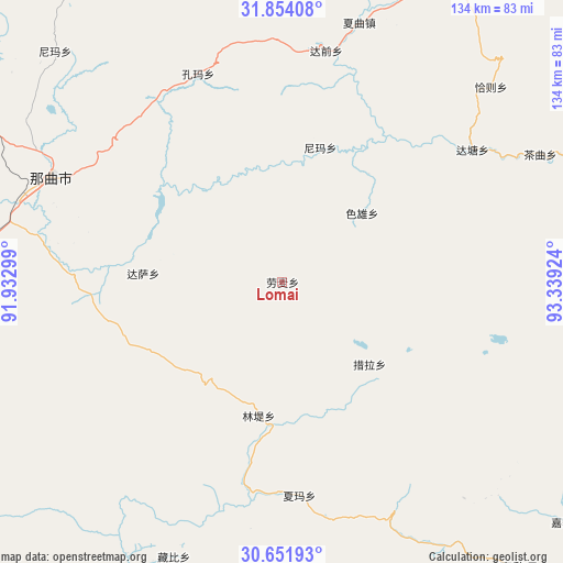
Lomai GPS coordinates[2]
31° 15' 17.712" North, 92° 38' 9.996" East
| Map corner | latitude | longitude |
|---|---|---|
| Upper-left | 31.85408°, | 91.93299° |
| Center: | 31.25492°, | 92.63611° |
| Lower-right: | 30.65193°, | 93.33924° |
| Map W x H: | 133.7×133.7 km | = 83.1×83.1mi |
| max Lat: | 53.31946° ⇑43.4% North |
| Lomai: | 31.25492° |
| min Lat: | ⇓56.6% South 18.22056° |
| min Long | Lomai | max Long |
| 75.07348° | 92.63611° | 134.28917° |
| W 3.3%⇐ | ⇒96.7% E |
Elevation
Elevation of Lomai is 4605 m = 15108 ft, and this is 4120.2 m = 13518 ft above average elevation for this country.
| Max E: |
5622 m = 18445 ft | 0.3% |
| Lomai | 4605 m 15108 ft | |
| Avg. | 484.8 m = 1591 ft | |
Min E: |
-3 m = -10 ft | 99.7% |
See also: China elevation on elevation.city.
Geographical zone
Lomai is located in North temperate zone (between Tropic of Cancer and the Arctic Circle). Distance of this Northern Tropic circle is 869.3 km =540.2 mi to South.| Distance of | km | miles | from Lomai |
|---|---|---|---|
| North Pole | 6531.8 | 4058.7 | to North |
| Arctic Circle | 3926 | 2439.5 | to North |
| Tropic Cancer | 869.3 | 540.2 | to South |
| Equator | 3475.2 | 2159.4 | to South |


Nearby cities:
15 places around Lomai: (largest is in red/bold)
• Caqu
68.2 km =42.4 mi,  63°
63°
• Cola
28.8 km =17.9 mi,  132°
132°
• Dagsar
33.1 km =20.6 mi,  273°
273°
• Daqian
55.8 km =34.7 mi,  11°
11°
• Kormang
53.2 km =33.1 mi,  337°
337°
• Lingti
33.5 km =20.8 mi,  189°
189°
• Nagqu
60.2 km =37.4 mi,  294°
294°
• Nagqu
62.3 km =38.7 mi, 285°
• Nyima
33.4 km =20.8 mi,  15°
15°
• Nyima
66.8 km =41.5 mi,  327°
327°
• Qiaze
71.8 km =44.6 mi,  45°
45°
• Sexiong
24.9 km =15.5 mi, 49°
• Xagqu
64.1 km =39.8 mi, 16°
• Xarma
51 km =31.7 mi,  175°
175°
• Zangbi
70.3 km =43.7 mi,  201°
201°
Sources, notices
• [Note1] Compared only with cities in China existing in our database
• [Src1] Map data: © OpenStreetMap contributors (CC-BY-SA)
• [Src2] Other city data from geonames.org with taken over terms of usage.
• [Src3] Geographical zone / Annual Mean Temperature by Robert A. Rohde @ Wikipedia
