Bayi geodata
Bayi (Tibet) is a seat of a fourth-order administrative division; located in China in Asia/Shanghai (GMT+8) time zone. In our database, there are 1268 cities with bigger population. Compared to other cities in China, 57.9% of cities are located further ↑North; 96.3% of cities are located further →East and 96.9% of cities have lower elevation than Bayi. Note1


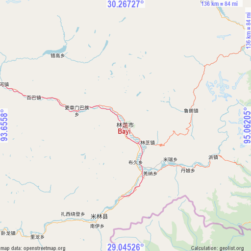
Bayi GPS coordinates[2]
29° 39' 29.232" North, 94° 21' 32.112" East
| Map corner | latitude | longitude |
|---|---|---|
| Upper-left | 30.26727°, | 93.6558° |
| Center: | 29.65812°, | 94.35892° |
| Lower-right: | 29.04526°, | 95.06205° |
| Map W x H: | 135.9×135.9 km | = 84.4×84.4mi |
| max Lat: | 53.31946° ⇑57.9% North |
| Bayi: | 29.65812° |
| min Lat: | ⇓42.1% South 18.22056° |
| min Long | Bayi | max Long |
| 75.07348° | 94.35892° | 134.28917° |
| W 3.7%⇐ | ⇒96.3% E |
Elevation
Elevation of Bayi is 2995 m = 9826 ft, and this is 2510.2 m = 8236 ft above average elevation for this country.
| Max E: |
5622 m = 18445 ft | 3.1% |
| Bayi | 2995 m 9826 ft | |
| Avg. | 484.8 m = 1591 ft | |
Min E: |
-3 m = -10 ft | 96.9% |
See also: China elevation on elevation.city.
Geographical zone
Bayi is located in North temperate zone (between Tropic of Cancer and the Arctic Circle). Distance of this Northern Tropic circle is 691.8 km =429.9 mi to South.| Distance of | km | miles | from Bayi |
|---|---|---|---|
| North Pole | 6709.4 | 4169 | to North |
| Arctic Circle | 4103.5 | 2549.8 | to North |
| Tropic Cancer | 691.8 | 429.9 | to South |
| Equator | 3297.7 | 2049.1 | to South |


Nearby cities:
15 places around Bayi: (largest is in red/bold)
• Baiba
51.4 km =31.9 mi,  287°
287°
• Damnyain
41 km =25.5 mi,  125°
125°
• Gengzhang
26.9 km =16.7 mi, 286°
• Lunang
36.4 km =22.6 mi,  76°
76°
• Mainling
51 km =31.7 mi,  196°
196°
• Mainri
30.2 km =18.8 mi, 126°
• Nailung
76.9 km =47.8 mi,  218°
218°
• Nanyi
55.3 km =34.4 mi, 197°
• Orong
86.4 km =53.7 mi,  226°
226°
• Paicun
50.1 km =31.1 mi,  109°
109°
• Puqu
21.7 km =13.5 mi,  164°
164°
• Tungdor
57.5 km =35.7 mi,  207°
207°
• Yinla
15 km =9.3 mi, 126°
• Zhaxirabdain
55.5 km =34.5 mi, 210°
• Zhongyu
98.6 km =61.3 mi,  339°
339°
Sources, notices
• [Note1] Compared only with cities in China existing in our database
• [Src1] Map data: © OpenStreetMap contributors (CC-BY-SA)
• [Src2] Other city data from geonames.org with taken over terms of usage.
• [Src3] Geographical zone / Annual Mean Temperature by Robert A. Rohde @ Wikipedia
