Baohe geodata
Baohe (Yunnan) is a seat of a third-order administrative division; located in China in Asia/Shanghai (GMT+8) time zone. In our database, there are 1268 cities with bigger population. Compared to other cities in China, 77.8% of cities are located further ↑North; 94.9% of cities are located further →East and 96.1% of cities have lower elevation than Baohe. Note1


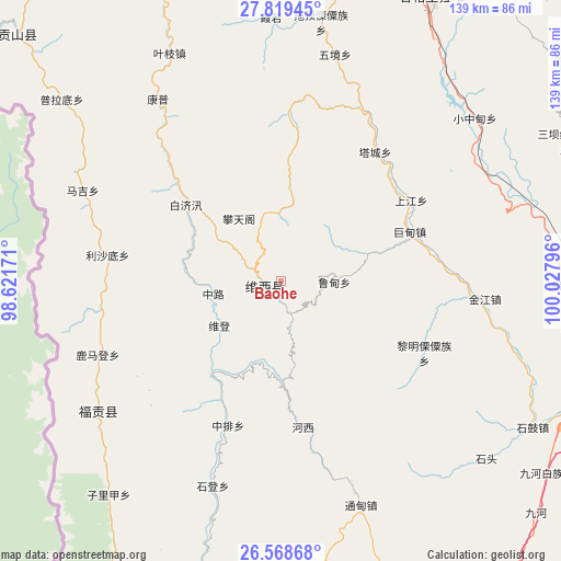
Baohe GPS coordinates[2]
27° 11' 44.952" North, 99° 19' 29.388" East
| Map corner | latitude | longitude |
|---|---|---|
| Upper-left | 27.81945°, | 98.62171° |
| Center: | 27.19582°, | 99.32483° |
| Lower-right: | 26.56868°, | 100.02796° |
| Map W x H: | 139.1×139.1 km | = 86.4×86.4mi |
| max Lat: | 53.31946° ⇑77.8% North |
| Baohe: | 27.19582° |
| min Lat: | ⇓22.2% South 18.22056° |
| min Long | Baohe | max Long |
| 75.07348° | 99.32483° | 134.28917° |
| W 5.1%⇐ | ⇒94.9% E |
Elevation
Elevation of Baohe is 2591 m = 8501 ft, and this is 2106.2 m = 6910 ft above average elevation for this country.
| Max E: |
5622 m = 18445 ft | 3.9% |
| Baohe | 2591 m 8501 ft | |
| Avg. | 484.8 m = 1591 ft | |
Min E: |
-3 m = -10 ft | 96.1% |
See also: China elevation on elevation.city.
Geographical zone
Baohe is located in North temperate zone (between Tropic of Cancer and the Arctic Circle). Distance of this Northern Tropic circle is 418 km =259.7 mi to South.| Distance of | km | miles | from Baohe |
|---|---|---|---|
| North Pole | 6983.2 | 4339.2 | to North |
| Arctic Circle | 4377.3 | 2719.9 | to North |
| Tropic Cancer | 418 | 259.7 | to South |
| Equator | 3023.9 | 1879 | to South |


Nearby cities:
15 places around Baohe: (largest is in red/bold)
• Badi
79.5 km =49.4 mi,  343°
343°
• Cikai
87.5 km =54.4 mi,  316°
316°
• Geluwan
38.2 km =23.7 mi,  58°
58°
• Jiantang
82.3 km =51.1 mi,  32°
32°
• Jinding
84.9 km =52.8 mi,  172°
172°
• Kaiwen
50.6 km =31.4 mi,  95°
95°
• Kangpu
49.6 km =30.8 mi,  333°
333°
• Shangpa
48.1 km =29.9 mi,  230°
230°
• Shangri-La
79.5 km =49.4 mi, 28°
• Shuijia
79.8 km =49.6 mi,  65°
65°
• Tuoding
64.3 km =40 mi,  13°
13°
• Wujing
60.1 km =37.3 mi,  20°
20°
• Xiaqiaotou
71.1 km =44.2 mi,  90°
90°
• Xiaruo
68.3 km =42.4 mi,  2°
2°
• Yezhi
59.6 km =37 mi, 340°
Sources, notices
• [Note1] Compared only with cities in China existing in our database
• [Src1] Map data: © OpenStreetMap contributors (CC-BY-SA)
• [Src2] Other city data from geonames.org with taken over terms of usage.
• [Src3] Geographical zone / Annual Mean Temperature by Robert A. Rohde @ Wikipedia
