Jinding geodata
Jinding (Yunnan) is a seat of a third-order administrative division; located in China in Asia/Shanghai (GMT+8) time zone. In our database, there are 1268 cities with bigger population. Compared to other cities in China, 80.7% of cities are located further ↑North; 94.9% of cities are located further →East and 95.9% of cities have lower elevation than Jinding. Note1


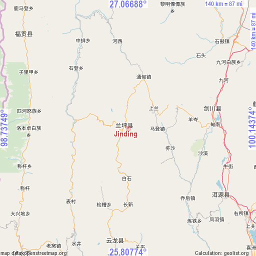
Jinding GPS coordinates[2]
26° 26' 20.508" North, 99° 26' 26.196" East
| Map corner | latitude | longitude |
|---|---|---|
| Upper-left | 27.06688°, | 98.73749° |
| Center: | 26.43903°, | 99.44061° |
| Lower-right: | 25.80774°, | 100.14374° |
| Map W x H: | 140×140 km | = 87×87mi |
| max Lat: | 53.31946° ⇑80.7% North |
| Jinding: | 26.43903° |
| min Lat: | ⇓19.3% South 18.22056° |
| min Long | Jinding | max Long |
| 75.07348° | 99.44061° | 134.28917° |
| W 5.1%⇐ | ⇒94.9% E |
Elevation
Elevation of Jinding is 2511 m = 8238 ft, and this is 2026.2 m = 6648 ft above average elevation for this country.
| Max E: |
5622 m = 18445 ft | 4.1% |
| Jinding | 2511 m 8238 ft | |
| Avg. | 484.8 m = 1591 ft | |
Min E: |
-3 m = -10 ft | 95.9% |
See also: China elevation on elevation.city.
Geographical zone
Jinding is located in North temperate zone (between Tropic of Cancer and the Arctic Circle). Distance of this Northern Tropic circle is 333.8 km =207.4 mi to South.| Distance of | km | miles | from Jinding |
|---|---|---|---|
| North Pole | 7067.3 | 4391.4 | to North |
| Arctic Circle | 4461.4 | 2772.2 | to North |
| Tropic Cancer | 333.8 | 207.4 | to South |
| Equator | 2939.7 | 1826.6 | to South |


Nearby cities:
15 places around Jinding: (largest is in red/bold)
• Baohe
84.9 km =52.8 mi,  352°
352°
• Dali
122.3 km =76 mi,  140°
140°
• Geluwan
106.1 km =65.9 mi,  11°
11°
• Huangshan
88.5 km =55 mi,  60°
60°
• Jinhua
48.7 km =30.3 mi,  76°
76°
• Kaiwen
88.8 km =55.2 mi,  26°
26°
• Laojie
110.8 km =68.8 mi,  174°
174°
• Lijiang
91.1 km =56.6 mi, 58°
• Luzhang
80.5 km =50 mi,  229°
229°
• Shangjie
101 km =62.8 mi,  147°
147°
• Shangpa
72.2 km =44.9 mi,  317°
317°
• Shimen
60.5 km =37.6 mi,  181°
181°
• Xiaqiaotou
102.3 km =63.6 mi,  35°
35°
• Yuhu
65.5 km =40.7 mi,  124°
124°
• Yunhe
76 km =47.2 mi, 82°
Sources, notices
• [Note1] Compared only with cities in China existing in our database
• [Src1] Map data: © OpenStreetMap contributors (CC-BY-SA)
• [Src2] Other city data from geonames.org with taken over terms of usage.
• [Src3] Geographical zone / Annual Mean Temperature by Robert A. Rohde @ Wikipedia
