Shangpa geodata
Shangpa (Yunnan) is a seat of a third-order administrative division; located in China in Asia/Shanghai (GMT+8) time zone. In our database, there are 1268 cities with bigger population. Compared to other cities in China, 78.9% of cities are located further ↑North; 95.1% of cities are located further →East and 96.9% of cities have lower elevation than Shangpa. Note1


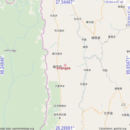
Shangpa GPS coordinates[2]
26° 55' 10.128" North, 98° 57' 5.688" East
| Map corner | latitude | longitude |
|---|---|---|
| Upper-left | 27.54467°, | 98.24846° |
| Center: | 26.91948°, | 98.95158° |
| Lower-right: | 26.29081°, | 99.65471° |
| Map W x H: | 139.4×139.4 km | = 86.6×86.6mi |
| max Lat: | 53.31946° ⇑78.9% North |
| Shangpa: | 26.91948° |
| min Lat: | ⇓21.1% South 18.22056° |
| min Long | Shangpa | max Long |
| 75.07348° | 98.95158° | 134.28917° |
| W 4.9%⇐ | ⇒95.1% E |
Elevation
Elevation of Shangpa is 2984 m = 9790 ft, and this is 2499.2 m = 8199 ft above average elevation for this country.
| Max E: |
5622 m = 18445 ft | 3.1% |
| Shangpa | 2984 m 9790 ft | |
| Avg. | 484.8 m = 1591 ft | |
Min E: |
-3 m = -10 ft | 96.9% |
See also: China elevation on elevation.city.
Geographical zone
Shangpa is located in North temperate zone (between Tropic of Cancer and the Arctic Circle). Distance of this Northern Tropic circle is 387.2 km =240.6 mi to South.| Distance of | km | miles | from Shangpa |
|---|---|---|---|
| North Pole | 7013.9 | 4358.2 | to North |
| Arctic Circle | 4408 | 2739 | to North |
| Tropic Cancer | 387.2 | 240.6 | to South |
| Equator | 2993.2 | 1859.9 | to South |


Nearby cities:
15 places around Shangpa: (largest is in red/bold)
• Badi
107.7 km =66.9 mi,  7°
7°
• Baohe
48.1 km =29.9 mi,  50°
50°
• Cikai
96.8 km =60.1 mi,  345°
345°
• Geluwan
86.1 km =53.5 mi, 54°
• Jinding
72.2 km =44.9 mi,  137°
137°
• Jinhua
104.9 km =65.2 mi,  113°
113°
• Kaiwen
91.3 km =56.7 mi,  73°
73°
• Kangpu
76.6 km =47.6 mi, 11°
• Luzhang
106 km =65.9 mi,  186°
186°
• Shimen
123.5 km =76.7 mi,  157°
157°
• Tuoding
106.6 km =66.2 mi,  28°
28°
• Wujing
104.5 km =64.9 mi, 33°
• Xiaqiaotou
112.1 km =69.7 mi, 74°
• Xiaruo
106.7 km =66.3 mi,  22°
22°
• Yezhi
88.7 km =55.1 mi, 11°
In other languages:
- In Chinese: Shang-p’a-chieh, Shang-p’a-ts’un, Shang-p’a, Shang-p’a-hsing-cheng-shu, 上帕
Sources, notices
• [Note1] Compared only with cities in China existing in our database
• [Src1] Map data: © OpenStreetMap contributors (CC-BY-SA)
• [Src2] Other city data from geonames.org with taken over terms of usage.
• [Src3] Geographical zone / Annual Mean Temperature by Robert A. Rohde @ Wikipedia
