Shangri-La geodata
Shangri-La (Yunnan) is a populated place; located in China in Asia/Shanghai (GMT+8) time zone. With population of 130,000 people, there are 339 cities with bigger population in this country. Compared to other cities in China, 75% of cities are located further ↑North; 94.7% of cities are located further →East and 97.4% of cities have lower elevation than Shangri-La. Note1


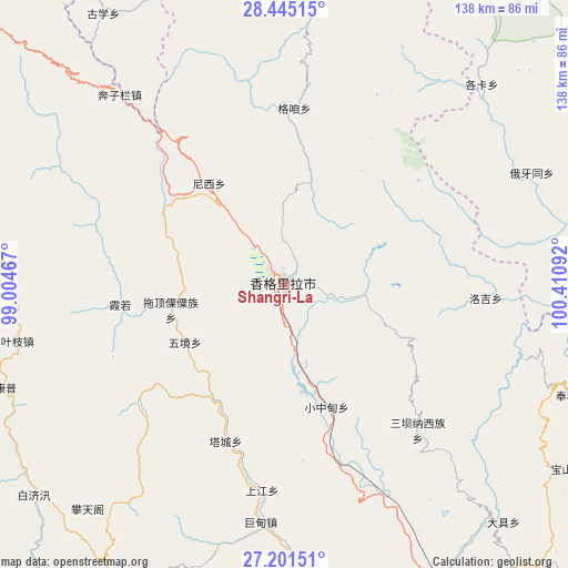
Shangri-La GPS coordinates[2]
27° 49' 30.396" North, 99° 42' 28.044" East
| Map corner | latitude | longitude |
|---|---|---|
| Upper-left | 28.44515°, | 99.00467° |
| Center: | 27.82511°, | 99.70779° |
| Lower-right: | 27.20151°, | 100.41092° |
| Map W x H: | 138.3×138.3 km | = 85.9×85.9mi |
| max Lat: | 53.31946° ⇑75% North |
| Shangri-La: | 27.82511° |
| min Lat: | ⇓25% South 18.22056° |
| min Long | Shangri-La | max Long |
| 75.07348° | 99.70779° | 134.28917° |
| W 5.3%⇐ | ⇒94.7% E |
Elevation
Elevation of Shangri-La is 3283 m = 10771 ft, and this is 2798.2 m = 9180 ft above average elevation for this country.
| Max E: |
5622 m = 18445 ft | 2.6% |
| Shangri-La | 3283 m 10771 ft | |
| Avg. | 484.8 m = 1591 ft | |
Min E: |
-3 m = -10 ft | 97.4% |
See also: Shangri-La elevation on elevation.city.
Geographical zone
Shangri-La is located in North temperate zone (between Tropic of Cancer and the Arctic Circle). Distance of this Northern Tropic circle is 487.9 km =303.2 mi to South.| Distance of | km | miles | from Shangri-La |
|---|---|---|---|
| North Pole | 6913.2 | 4295.7 | to North |
| Arctic Circle | 4307.3 | 2676.4 | to North |
| Tropic Cancer | 487.9 | 303.2 | to South |
| Equator | 3093.9 | 1922.5 | to South |


Nearby cities:
15 places around Shangri-La: (largest is in red/bold)
• Badi
61 km =37.9 mi,  275°
275°
• Bengshutang
30.6 km =19 mi,  320°
320°
• Benzilan
56.5 km =35.1 mi, 323°
• Geluwan
50.4 km =31.3 mi,  185°
185°
• Gezan
43.3 km =26.9 mi,  13°
13°
• Jiantang
6.1 km =3.8 mi,  92°
92°
• Kangpu
64.9 km =40.3 mi,  246°
246°
• Lazanzhong
44.1 km =27.4 mi,  3°
3°
• Shuijia
51.3 km =31.9 mi,  136°
136°
• Tuoding
24.4 km =15.2 mi, 252°
• Wujing
21.6 km =13.4 mi,  230°
230°
• Xiaruo
34.5 km =21.4 mi,  267°
267°
• Yanmen
72.6 km =45.1 mi,  292°
292°
• Yezhi
58.8 km =36.5 mi,  256°
256°
• Zhongcun
49 km =30.4 mi, 93°
Sources, notices
• [Note1] Compared only with cities in China existing in our database
• [Src1] Map data: © OpenStreetMap contributors (CC-BY-SA)
• [Src2] Other city data from geonames.org with taken over terms of usage.
• [Src3] Geographical zone / Annual Mean Temperature by Robert A. Rohde @ Wikipedia
