Kangpu geodata
Kangpu (Yunnan) is a seat of a fourth-order administrative division; located in China in Asia/Shanghai (GMT+8) time zone. In our database, there are 1268 cities with bigger population. Compared to other cities in China, 76.2% of cities are located further ↑North; 95% of cities are located further →East and 96.5% of cities have lower elevation than Kangpu. Note1


Kangpu GPS coordinates[2]
27° 35' 43.8" North, 99° 6' 5.148" East
| Map corner | latitude | longitude |
|---|---|---|
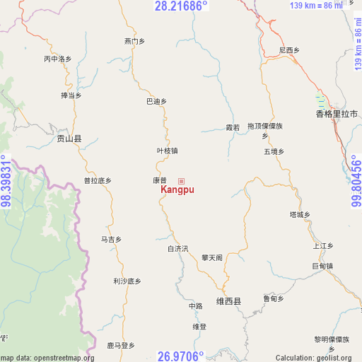
| Upper-left | 28.21686°, | 98.39831° |
| Center: | 27.5955°, | 99.10143° |
| Lower-right: | 26.9706°, | 99.80456° |
| Map W x H: | 138.6×138.6 km | = 86.1×86.1mi |
| max Lat: | 53.31946° ⇑76.2% North |
| Kangpu: | 27.5955° |
| min Lat: | ⇓23.8% South 18.22056° |
| min Long | Kangpu | max Long |
| 75.07348° | 99.10143° | 134.28917° |
| W 5%⇐ | ⇒95% E |
Elevation
Elevation of Kangpu is 2800 m = 9186 ft, and this is 2315.2 m = 7596 ft above average elevation for this country.
| Max E: |
5622 m = 18445 ft | 3.5% |
| Kangpu | 2800 m 9186 ft | |
| Avg. | 484.8 m = 1591 ft | |
Min E: |
-3 m = -10 ft | 96.5% |
See also: China elevation on elevation.city.
Geographical zone
Kangpu is located in North temperate zone (between Tropic of Cancer and the Arctic Circle). Distance of this Northern Tropic circle is 462.4 km =287.3 mi to South.| Distance of | km | miles | from Kangpu |
|---|---|---|---|
| North Pole | 6938.7 | 4311.5 | to North |
| Arctic Circle | 4332.8 | 2692.3 | to North |
| Tropic Cancer | 462.4 | 287.3 | to South |
| Equator | 3068.3 | 1906.6 | to South |


Nearby cities:
15 places around Kangpu: (largest is in red/bold)
• Badi
31.7 km =19.7 mi,  358°
358°
• Baohe
49.6 km =30.8 mi,  153°
153°
• Bengshutang
63.3 km =39.3 mi,  39°
39°
• Benzilan
75.9 km =47.2 mi,  20°
20°
• Cikai
42.7 km =26.5 mi,  295°
295°
• Geluwan
60 km =37.3 mi,  114°
114°
• Jiantang
70.4 km =43.7 mi,  69°
69°
• Shangpa
76.6 km =47.6 mi,  191°
191°
• Shangri-La
64.9 km =40.3 mi, 66°
• Tuoding
40.7 km =25.3 mi,  63°
63°
• Wujing
44.5 km =27.7 mi, 74°
• Xiaruo
34.6 km =21.5 mi,  46°
46°
• Yanmen
53.6 km =33.3 mi,  351°
351°
• Yezhi
12.1 km =7.5 mi,  11°
11°
• Yunling
78.6 km =48.8 mi, 350°
Sources, notices
• [Note1] Compared only with cities in China existing in our database
• [Src1] Map data: © OpenStreetMap contributors (CC-BY-SA)
• [Src2] Other city data from geonames.org with taken over terms of usage.
• [Src3] Geographical zone / Annual Mean Temperature by Robert A. Rohde @ Wikipedia
