Manasi geodata
Manasi (Xinjiang) is a seat of a fourth-order administrative division; located in China in Asia/Urumqi (GMT+6) time zone. In our database, there are 1268 cities with bigger population. Compared to other cities in China, 93.2% of cities are located further ↓South; 98.3% of cities are located further →East and 72.6% of cities have lower elevation than Manasi. Note1


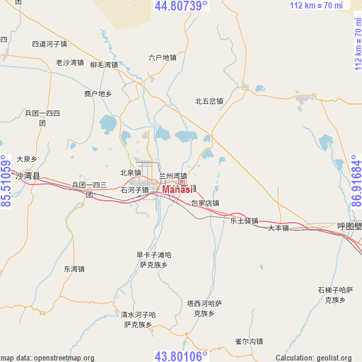
Manasi GPS coordinates[2]
44° 18' 22.968" North, 86° 12' 49.356" East
| Map corner | latitude | longitude |
|---|---|---|
| Upper-left | 44.80739°, | 85.51059° |
| Center: | 44.30638°, | 86.21371° |
| Lower-right: | 43.80106°, | 86.91684° |
| Map W x H: | 111.9×111.9 km | = 69.5×69.5mi |
| max Lat: | 53.31946° ⇑6.8% North |
| Manasi: | 44.30638° |
| min Lat: | ⇓93.2% South 18.22056° |
| min Long | Manasi | max Long |
| 75.07348° | 86.21371° | 134.28917° |
| W 1.7%⇐ | ⇒98.3% E |
Elevation
Elevation of Manasi is 465 m = 1526 ft, and this is 19.8 m = 65 ft below average elevation for this country.
| Max E: |
5622 m = 18445 ft | 27.4% |
| Avg. | 484.8 m = 1591 ft | |
| Manasi | 465 m = 1526 ft | |
Min E: |
-3 m = -10 ft | 72.6% |
See also: China elevation on elevation.city.
Geographical zone
Manasi is located in North temperate zone (between Tropic of Cancer and the Arctic Circle). Distance of this Northern Tropic circle is 2320.5 km =1441.9 mi to South.| Distance of | km | miles | from Manasi |
|---|---|---|---|
| North Pole | 5080.7 | 3157 | to North |
| Arctic Circle | 2474.8 | 1537.8 | to North |
| Tropic Cancer | 2320.5 | 1441.9 | to South |
| Equator | 4926.4 | 3061.1 | to South |


Nearby cities:
15 places around Manasi: (largest is in red/bold)
• Baojiadian
9.8 km =6.1 mi,  130°
130°
• Beiquan
16.4 km =10.2 mi,  281°
281°
• Beiwucha
26.4 km =16.4 mi,  18°
18°
• Dafeng
33.2 km =20.6 mi,  115°
115°
• Dongwan
42.4 km =26.3 mi,  230°
230°
• Guangdongdi
5.4 km =3.4 mi,  25°
25°
• Hankazi
23.7 km =14.7 mi,  197°
197°
• Jingouhe
42.1 km =26.2 mi,  271°
271°
• Letuyi
22.8 km =14.2 mi, 121°
• Liumaowan
40.8 km =25.4 mi,  323°
323°
• Sandaohezi
47.3 km =29.4 mi, 272°
• Shanghudi
36.9 km =22.9 mi,  312°
312°
• Shihezi
14.1 km =8.8 mi, 268°
• Ulan Us
28.4 km =17.6 mi, 265°
• Wugongtai
48.1 km =29.9 mi,  105°
105°
Sources, notices
• [Note1] Compared only with cities in China existing in our database
• [Src1] Map data: © OpenStreetMap contributors (CC-BY-SA)
• [Src2] Other city data from geonames.org with taken over terms of usage.
• [Src3] Geographical zone / Annual Mean Temperature by Robert A. Rohde @ Wikipedia
