Araltobe geodata
Araltobe (Xinjiang) is a seat of a fourth-order administrative division; located in China in Asia/Urumqi (GMT+6) time zone. In our database, there are 1268 cities with bigger population. Compared to other cities in China, 95.9% of cities are located further ↓South; 97.1% of cities are located further →East and 87.7% of cities have lower elevation than Araltobe. Note1


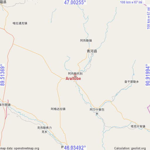
Araltobe GPS coordinates[2]
46° 31' 15.204" North, 90° 13' 0.516" East
| Map corner | latitude | longitude |
|---|---|---|
| Upper-left | 47.00255°, | 89.51369° |
| Center: | 46.52089°, | 90.21681° |
| Lower-right: | 46.03492°, | 90.91994° |
| Map W x H: | 107.6×107.6 km | = 66.9×66.9mi |
| max Lat: | 53.31946° ⇑4.1% North |
| Araltobe: | 46.52089° |
| min Lat: | ⇓95.9% South 18.22056° |
| min Long | Araltobe | max Long |
| 75.07348° | 90.21681° | 134.28917° |
| W 2.9%⇐ | ⇒97.1% E |
Elevation
Elevation of Araltobe is 1158 m = 3799 ft, and this is 673.2 m = 2209 ft above average elevation for this country.
| Max E: |
5622 m = 18445 ft | 12.3% |
| Araltobe | 1158 m 3799 ft | |
| Avg. | 484.8 m = 1591 ft | |
Min E: |
-3 m = -10 ft | 87.7% |
See also: China elevation on elevation.city.
Geographical zone
Araltobe is located in North temperate zone (between Tropic of Cancer and the Arctic Circle). Distance of this North polar circle is 2228.5 km =1384.7 mi to North.| Distance of | km | miles | from Araltobe |
|---|---|---|---|
| North Pole | 4834.4 | 3004 | to North |
| Arctic Circle | 2228.5 | 1384.7 | to North |
| Tropic Cancer | 2566.7 | 1594.9 | to South |
| Equator | 5172.6 | 3214.1 | to South |


Nearby cities:
15 places around Araltobe: (largest is in red/bold)
• Agax Obo
30.4 km =18.9 mi,  148°
148°
• Arele
26.3 km =16.3 mi,  15°
15°
• Dure
134.9 km =83.8 mi,  263°
263°
• Ertai
51.9 km =32.2 mi,  185°
185°
• Haramgai
187.3 km =116.4 mi,  274°
274°
• Kalabulegen
117.9 km =73.3 mi, 264°
• Kalatongke
54.4 km =33.8 mi,  313°
313°
• Koktokay
83.1 km =51.6 mi,  338°
338°
• Kürti
102.5 km =63.7 mi,  317°
317°
• Qagan Gol
40.7 km =25.3 mi,  96°
96°
• Qahurt
52.2 km =32.4 mi,  246°
246°
• Qinghe
20.4 km =12.7 mi,  37°
37°
• Takeshiken
58.4 km =36.3 mi,  129°
129°
• Temeke
85.9 km =53.4 mi, 335°
• Turgun
58.4 km =36.3 mi,  330°
330°
Sources, notices
• [Note1] Compared only with cities in China existing in our database
• [Src1] Map data: © OpenStreetMap contributors (CC-BY-SA)
• [Src2] Other city data from geonames.org with taken over terms of usage.
• [Src3] Geographical zone / Annual Mean Temperature by Robert A. Rohde @ Wikipedia
