Turgun geodata
Turgun (Xinjiang) is a seat of a fourth-order administrative division; located in China in Asia/Urumqi (GMT+6) time zone. In our database, there are 1268 cities with bigger population. Compared to other cities in China, 96.9% of cities are located further ↓South; 97.2% of cities are located further →East and 89.9% of cities have lower elevation than Turgun. Note1


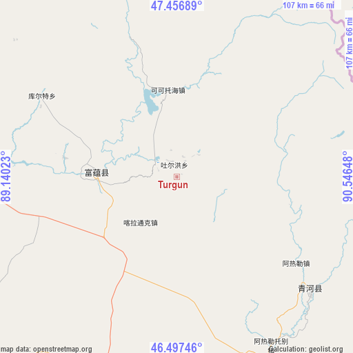
Turgun GPS coordinates[2]
46° 58' 45.588" North, 89° 50' 36.06" East
| Map corner | latitude | longitude |
|---|---|---|
| Upper-left | 47.45689°, | 89.14023° |
| Center: | 46.97933°, | 89.84335° |
| Lower-right: | 46.49746°, | 90.54648° |
| Map W x H: | 106.7×106.7 km | = 66.3×66.3mi |
| max Lat: | 53.31946° ⇑3.1% North |
| Turgun: | 46.97933° |
| min Lat: | ⇓96.9% South 18.22056° |
| min Long | Turgun | max Long |
| 75.07348° | 89.84335° | 134.28917° |
| W 2.8%⇐ | ⇒97.2% E |
Elevation
Elevation of Turgun is 1352 m = 4436 ft, and this is 867.2 m = 2845 ft above average elevation for this country.
| Max E: |
5622 m = 18445 ft | 10.1% |
| Turgun | 1352 m 4436 ft | |
| Avg. | 484.8 m = 1591 ft | |
Min E: |
-3 m = -10 ft | 89.9% |
See also: China elevation on elevation.city.
Geographical zone
Turgun is located in North temperate zone (between Tropic of Cancer and the Arctic Circle). Distance of this North polar circle is 2177.6 km =1353.1 mi to North.| Distance of | km | miles | from Turgun |
|---|---|---|---|
| North Pole | 4783.5 | 2972.3 | to North |
| Arctic Circle | 2177.6 | 1353.1 | to North |
| Tropic Cancer | 2617.7 | 1626.6 | to South |
| Equator | 5223.6 | 3245.8 | to South |


Nearby cities:
15 places around Turgun: (largest is in red/bold)
• Agax Obo
88.8 km =55.2 mi,  150°
150°
• Araltobe
58.4 km =36.3 mi, 150°
• Arele
43.9 km =27.3 mi,  125°
125°
• Dure
124.4 km =77.3 mi,  237°
237°
• Ertai
105.3 km =65.4 mi,  167°
167°
• Handegate
140.9 km =87.6 mi,  308°
308°
• Kalabulegen
108.4 km =67.4 mi,  234°
234°
• Kalatongke
17.6 km =10.9 mi,  218°
218°
• Koktokay
26.4 km =16.4 mi,  355°
355°
• Kürti
47.6 km =29.6 mi,  301°
301°
• Qagan Gol
88.4 km =54.9 mi, 128°
• Qahurt
74.3 km =46.2 mi,  194°
194°
• Qinghe
53.5 km =33.2 mi, 130°
• Takeshiken
114.6 km =71.2 mi,  140°
140°
• Temeke
28.1 km =17.5 mi,  344°
344°
Sources, notices
• [Note1] Compared only with cities in China existing in our database
• [Src1] Map data: © OpenStreetMap contributors (CC-BY-SA)
• [Src2] Other city data from geonames.org with taken over terms of usage.
• [Src3] Geographical zone / Annual Mean Temperature by Robert A. Rohde @ Wikipedia
