Kalatongke geodata
Kalatongke (Xinjiang) is a seat of a fourth-order administrative division; located in China in Asia/Urumqi (GMT+6) time zone. In our database, there are 1268 cities with bigger population. Compared to other cities in China, 96.6% of cities are located further ↓South; 97.3% of cities are located further →East and 84.1% of cities have lower elevation than Kalatongke. Note1


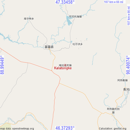
Kalatongke GPS coordinates[2]
46° 51' 21.276" North, 89° 41' 51.396" East
| Map corner | latitude | longitude |
|---|---|---|
| Upper-left | 47.33458°, | 88.99449° |
| Center: | 46.85591°, | 89.69761° |
| Lower-right: | 46.37293°, | 90.40074° |
| Map W x H: | 106.9×106.9 km | = 66.4×66.4mi |
| max Lat: | 53.31946° ⇑3.4% North |
| Kalatongke: | 46.85591° |
| min Lat: | ⇓96.6% South 18.22056° |
| min Long | Kalatongke | max Long |
| 75.07348° | 89.69761° | 134.28917° |
| W 2.7%⇐ | ⇒97.3% E |
Elevation
Elevation of Kalatongke is 919 m = 3015 ft, and this is 434.2 m = 1425 ft above average elevation for this country.
| Max E: |
5622 m = 18445 ft | 15.9% |
| Kalatongke | 919 m 3015 ft | |
| Avg. | 484.8 m = 1591 ft | |
Min E: |
-3 m = -10 ft | 84.1% |
See also: China elevation on elevation.city.
Geographical zone
Kalatongke is located in North temperate zone (between Tropic of Cancer and the Arctic Circle). Distance of this North polar circle is 2191.3 km =1361.6 mi to North.| Distance of | km | miles | from Kalatongke |
|---|---|---|---|
| North Pole | 4797.2 | 2980.8 | to North |
| Arctic Circle | 2191.3 | 1361.6 | to North |
| Tropic Cancer | 2604 | 1618.1 | to South |
| Equator | 5209.9 | 3237.3 | to South |


Nearby cities:
15 places around Kalatongke: (largest is in red/bold)
• Agax Obo
84.1 km =52.3 mi,  138°
138°
• Araltobe
54.4 km =33.8 mi,  133°
133°
• Arele
48.2 km =30 mi,  104°
104°
• Dure
107.9 km =67 mi,  240°
240°
• Ertai
95.4 km =59.3 mi,  158°
158°
• Kalabulegen
91.6 km =56.9 mi, 237°
• Koktokay
41.1 km =25.5 mi,  12°
12°
• Kürti
48.5 km =30.1 mi,  322°
322°
• Qagan Gol
90.2 km =56 mi,  117°
117°
• Qahurt
58.6 km =36.4 mi,  187°
187°
• Qinghe
56 km =34.8 mi,  112°
112°
• Takeshiken
112.7 km =70 mi, 131°
• Temeke
40.9 km =25.4 mi,  4°
4°
• Turgun
17.6 km =10.9 mi,  38°
38°
• Xirikxiy
138.7 km =86.2 mi,  293°
293°
Sources, notices
• [Note1] Compared only with cities in China existing in our database
• [Src1] Map data: © OpenStreetMap contributors (CC-BY-SA)
• [Src2] Other city data from geonames.org with taken over terms of usage.
• [Src3] Geographical zone / Annual Mean Temperature by Robert A. Rohde @ Wikipedia
