Koktokay geodata
Koktokay (Xinjiang) is a seat of a fourth-order administrative division; located in China in Asia/Urumqi (GMT+6) time zone. In our database, there are 1268 cities with bigger population. Compared to other cities in China, 97.4% of cities are located further ↓South; 97.2% of cities are located further →East and 88% of cities have lower elevation than Koktokay. Note1


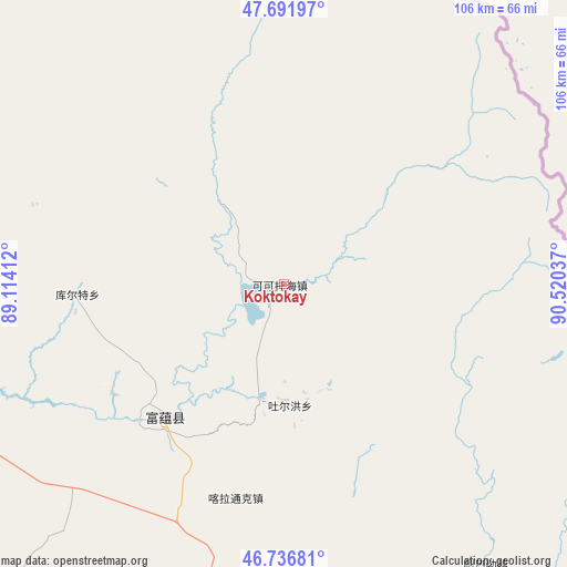
Koktokay GPS coordinates[2]
47° 12' 59.544" North, 89° 49' 2.064" East
| Map corner | latitude | longitude |
|---|---|---|
| Upper-left | 47.69197°, | 89.11412° |
| Center: | 47.21654°, | 89.81724° |
| Lower-right: | 46.73681°, | 90.52037° |
| Map W x H: | 106.2×106.2 km | = 66×66mi |
| max Lat: | 53.31946° ⇑2.6% North |
| Koktokay: | 47.21654° |
| min Lat: | ⇓97.4% South 18.22056° |
| min Long | Koktokay | max Long |
| 75.07348° | 89.81724° | 134.28917° |
| W 2.8%⇐ | ⇒97.2% E |
Elevation
Elevation of Koktokay is 1181 m = 3875 ft, and this is 696.2 m = 2284 ft above average elevation for this country.
| Max E: |
5622 m = 18445 ft | 12% |
| Koktokay | 1181 m 3875 ft | |
| Avg. | 484.8 m = 1591 ft | |
Min E: |
-3 m = -10 ft | 88% |
See also: China elevation on elevation.city.
Geographical zone
Koktokay is located in North temperate zone (between Tropic of Cancer and the Arctic Circle). Distance of this North polar circle is 2151.2 km =1336.7 mi to North.| Distance of | km | miles | from Koktokay |
|---|---|---|---|
| North Pole | 4757.1 | 2955.9 | to North |
| Arctic Circle | 2151.2 | 1336.7 | to North |
| Tropic Cancer | 2644.1 | 1643 | to South |
| Equator | 5250 | 3262.2 | to South |


Nearby cities:
15 places around Koktokay: (largest is in red/bold)
• Agax Obo
113.2 km =70.3 mi,  156°
156°
• Araltobe
83.1 km =51.6 mi, 158°
• Arele
64.2 km =39.9 mi,  144°
144°
• Ertai
131.5 km =81.7 mi,  168°
168°
• Handegate
124.2 km =77.2 mi,  299°
299°
• Hongdun
132.8 km =82.5 mi, 295°
• Kalabulegen
124.1 km =77.1 mi,  223°
223°
• Kalatongke
41.1 km =25.5 mi,  192°
192°
• Kürti
38.7 km =24 mi,  267°
267°
• Qagan Gol
108.1 km =67.2 mi, 139°
• Qahurt
99.6 km =61.9 mi, 189°
• Qinghe
74.5 km =46.3 mi,  145°
145°
• Temeke
5.7 km =3.5 mi,  276°
276°
• Turgun
26.4 km =16.4 mi,  175°
175°
• Xirikxiy
136.6 km =84.9 mi, 276°
Sources, notices
• [Note1] Compared only with cities in China existing in our database
• [Src1] Map data: © OpenStreetMap contributors (CC-BY-SA)
• [Src2] Other city data from geonames.org with taken over terms of usage.
• [Src3] Geographical zone / Annual Mean Temperature by Robert A. Rohde @ Wikipedia
