Yarumal geodata
Yarumal (Antioquia) is a seat of a second-order administrative division; located in Colombia in America/Bogota (GMT-5) time zone. With population of 22,368 people, there are 163 cities with bigger population in this country. Compared to other cities in Colombia, 73.7% of cities are located further ↓South; 64.2% of cities are located further →East and 84.9% of cities have lower elevation than Yarumal. Note1


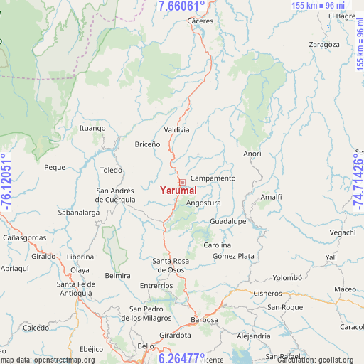
Yarumal GPS coordinates[2]
6° 57' 47.556" North, 75° 25' 2.568" West
| Map corner | latitude | longitude |
|---|---|---|
| Upper-left | 7.66061°, | -76.12051° |
| Center: | 6.96321°, | -75.41738° |
| Lower-right: | 6.26477°, | -74.71426° |
| Map W x H: | 155.2×155.2 km | = 96.4×96.4mi |
| max Lat: | 13.38166° ⇑26.3% North |
| Yarumal: | 6.96321° |
| min Lat: | ⇓73.7% South -4.21528° |
| min Long | Yarumal | max Long |
| -81.70636° | -75.41738° | -67.06996° |
| W 35.8%⇐ | ⇒64.2% E |
Elevation
Elevation of Yarumal is 2276 m = 7467 ft, and this is 1126.7 m = 3697 ft above average elevation for this country.
| Max E: |
3342 m = 10965 ft | 15.1% |
| Yarumal | 2276 m 7467 ft | |
| Avg. | 1149.3 m = 3771 ft | |
Min E: |
1 m = 3 ft | 84.9% |
See also: Colombia elevation on elevation.city.
Geographical zone
Yarumal is located in North Torrid zone (between Equator and Tropic of Cancer). Distance of Equator is 774.2 km =481.1 mi to South.| Distance of | km | miles | from Yarumal |
|---|---|---|---|
| North Pole | 9232.8 | 5737 | to North |
| Arctic Circle | 6626.9 | 4117.8 | to North |
| Tropic Cancer | 1831.7 | 1138.2 | to North |
| Equator | 774.2 | 481.1 | to South |


Nearby cities:
15 places around Yarumal: (largest is in red/bold)
• Amalfi
38 km =23.6 mi,  98°
98°
• Angostura
12.6 km =7.8 mi,  133°
133°
• Anorí
32.2 km =20 mi,  67°
67°
• Briceño
22.1 km =13.7 mi,  317°
317°
• Campamento
13.4 km =8.3 mi,  82°
82°
• Carolina
30.5 km =19 mi,  150°
150°
• Guadalupe
25.6 km =15.9 mi, 130°
• Gómez Plata
38.2 km =23.7 mi, 145°
• Ituango
44.7 km =27.8 mi,  301°
301°
• San Andrés
30 km =18.6 mi,  257°
257°
• San José de la Montaña
31.9 km =19.8 mi,  246°
246°
• Santa Rosa de Osos
35.4 km =22 mi,  187°
187°
• Toledo
31.2 km =19.4 mi,  280°
280°
• Valdivia
22.5 km =14 mi,  353°
353°
• Valdivia
36.9 km =22.9 mi,  4°
4°
Sources, notices
• [Note1] Compared only with cities in Colombia existing in our database
• [Src1] Map data: © OpenStreetMap contributors (CC-BY-SA)
• [Src2] Other city data from geonames.org with taken over terms of usage.
• [Src3] Geographical zone / Annual Mean Temperature by Robert A. Rohde @ Wikipedia
