Anorí geodata
Anorí (Antioquia) is a seat of a second-order administrative division; located in Colombia in America/Bogota (GMT-5) time zone. In our database, there are 1053 cities with bigger population. Compared to other cities in Colombia, 75% of cities are located further ↓South; 57.9% of cities are located further →East and 64.8% of cities have lower elevation than Anorí. Note1


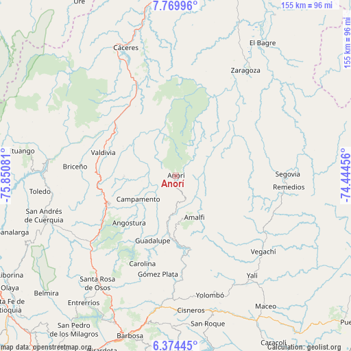
Anorí GPS coordinates[2]
7° 4' 21.828" North, 75° 8' 51.648" West
| Map corner | latitude | longitude |
|---|---|---|
| Upper-left | 7.76996°, | -75.85081° |
| Center: | 7.07273°, | -75.14768° |
| Lower-right: | 6.37445°, | -74.44456° |
| Map W x H: | 155.2×155.2 km | = 96.4×96.4mi |
| max Lat: | 13.38166° ⇑25% North |
| Anorí: | 7.07273° |
| min Lat: | ⇓75% South -4.21528° |
| min Long | Anorí | max Long |
| -81.70636° | -75.14768° | -67.06996° |
| W 42.1%⇐ | ⇒57.9% E |
Elevation
Elevation of Anorí is 1585 m = 5200 ft, and this is 435.7 m = 1429 ft above average elevation for this country.
| Max E: |
3342 m = 10965 ft | 35.2% |
| Anorí | 1585 m 5200 ft | |
| Avg. | 1149.3 m = 3771 ft | |
Min E: |
1 m = 3 ft | 64.8% |
See also: Colombia elevation on elevation.city.
Geographical zone
Anorí is located in North Torrid zone (between Equator and Tropic of Cancer). Distance of Equator is 786.4 km =488.6 mi to South.| Distance of | km | miles | from Anorí |
|---|---|---|---|
| North Pole | 9220.6 | 5729.4 | to North |
| Arctic Circle | 6614.8 | 4110.2 | to North |
| Tropic Cancer | 1819.5 | 1130.6 | to North |
| Equator | 786.4 | 488.6 | to South |


Nearby cities:
15 places around Anorí: (largest is in red/bold)
• Amalfi
19.7 km =12.2 mi,  156°
156°
• Angostura
29.3 km =18.2 mi,  224°
224°
• Briceño
44.8 km =27.8 mi,  275°
275°
• Campamento
19.5 km =12.1 mi,  237°
237°
• Carolina
41.5 km =25.8 mi,  200°
200°
• Cruces de Anorí
15.2 km =9.4 mi,  36°
36°
• Guadalupe
30.5 km =19 mi, 199°
• Gómez Plata
44.2 km =27.5 mi,  190°
190°
• Remedios
50.3 km =31.3 mi,  95°
95°
• Segovia
49.5 km =30.8 mi,  89°
89°
• Valdivia
33.7 km =20.9 mi,  287°
287°
• Valdivia
36.5 km =22.7 mi,  312°
312°
• Vegachí
52.1 km =32.4 mi,  131°
131°
• Yarumal
32.2 km =20 mi,  247°
247°
• Yolombó
54.8 km =34.1 mi, 164°
Sources, notices
• [Note1] Compared only with cities in Colombia existing in our database
• [Src1] Map data: © OpenStreetMap contributors (CC-BY-SA)
• [Src2] Other city data from geonames.org with taken over terms of usage.
• [Src3] Geographical zone / Annual Mean Temperature by Robert A. Rohde @ Wikipedia
