Briceño geodata
Briceño (Antioquia) is a seat of a second-order administrative division; located in Colombia in America/Bogota (GMT-5) time zone. With population of 2,214 people, there are 775 cities with bigger population in this country. Compared to other cities in Colombia, 75.4% of cities are located further ↓South; 67.7% of cities are located further →East and 53.1% of cities have lower elevation than Briceño. Note1


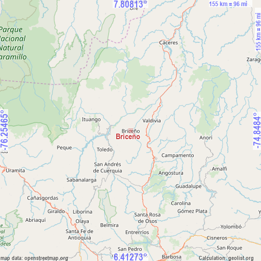
Briceño GPS coordinates[2]
7° 6' 39.456" North, 75° 33' 5.472" West
| Map corner | latitude | longitude |
|---|---|---|
| Upper-left | 7.80813°, | -76.25465° |
| Center: | 7.11096°, | -75.55152° |
| Lower-right: | 6.41273°, | -74.8484° |
| Map W x H: | 155.2×155.2 km | = 96.4×96.4mi |
| max Lat: | 13.38166° ⇑24.6% North |
| Briceño: | 7.11096° |
| min Lat: | ⇓75.4% South -4.21528° |
| min Long | Briceño | max Long |
| -81.70636° | -75.55152° | -67.06996° |
| W 32.3%⇐ | ⇒67.7% E |
Elevation
Elevation of Briceño is 1240 m = 4068 ft, and this is 90.7 m = 298 ft above average elevation for this country.
| Max E: |
3342 m = 10965 ft | 46.9% |
| Briceño | 1240 m 4068 ft | |
| Avg. | 1149.3 m = 3771 ft | |
Min E: |
1 m = 3 ft | 53.1% |
See also: Colombia elevation on elevation.city.
Geographical zone
Briceño is located in North Torrid zone (between Equator and Tropic of Cancer). Distance of Equator is 790.7 km =491.3 mi to South.| Distance of | km | miles | from Briceño |
|---|---|---|---|
| North Pole | 9216.4 | 5726.8 | to North |
| Arctic Circle | 6610.5 | 4107.6 | to North |
| Tropic Cancer | 1815.3 | 1128 | to North |
| Equator | 790.7 | 491.3 | to South |


Nearby cities:
15 places around Briceño: (largest is in red/bold)
• Angostura
34.7 km =21.6 mi,  136°
136°
• Anorí
44.8 km =27.8 mi,  95°
95°
• Campamento
31.7 km =19.7 mi,  117°
117°
• Carolina
52.3 km =32.5 mi,  145°
145°
• Guadalupe
47.6 km =29.6 mi,  133°
133°
• Ituango
24.4 km =15.2 mi,  285°
285°
• Peque
40.7 km =25.3 mi,  255°
255°
• Sabanalarga
41.3 km =25.7 mi,  225°
225°
• San Andrés
27.2 km =16.9 mi,  212°
212°
• San José de la Montaña
32.4 km =20.1 mi, 206°
• Santa Rosa de Osos
52.5 km =32.6 mi,  168°
168°
• Toledo
19.2 km =11.9 mi,  235°
235°
• Valdivia
13.8 km =8.6 mi,  64°
64°
• Valdivia
26.9 km =16.7 mi,  40°
40°
• Yarumal
22.1 km =13.7 mi, 137°
Sources, notices
• [Note1] Compared only with cities in Colombia existing in our database
• [Src1] Map data: © OpenStreetMap contributors (CC-BY-SA)
• [Src2] Other city data from geonames.org with taken over terms of usage.
• [Src3] Geographical zone / Annual Mean Temperature by Robert A. Rohde @ Wikipedia
