Valdivia geodata
Valdivia (Antioquia) is a seat of a second-order administrative division; located in Colombia in America/Bogota (GMT-5) time zone. In our database, there are 1053 cities with bigger population. Compared to other cities in Colombia, 75.8% of cities are located further ↓South; 64.9% of cities are located further →East and 58.1% of cities have higher elevation than Valdivia. Note1


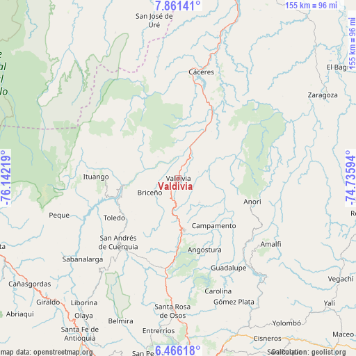
Valdivia GPS coordinates[2]
7° 9' 51.588" North, 75° 26' 20.616" West
| Map corner | latitude | longitude |
|---|---|---|
| Upper-left | 7.86141°, | -76.14219° |
| Center: | 7.16433°, | -75.43906° |
| Lower-right: | 6.46618°, | -74.73594° |
| Map W x H: | 155.1×155.1 km | = 96.4×96.4mi |
| max Lat: | 13.38166° ⇑24.2% North |
| Valdivia: | 7.16433° |
| min Lat: | ⇓75.8% South -4.21528° |
| min Long | Valdivia | max Long |
| -81.70636° | -75.43906° | -67.06996° |
| W 35.1%⇐ | ⇒64.9% E |
Elevation
Elevation of Valdivia is 885 m = 2904 ft, and this is 264.3 m = 867 ft below average elevation for this country.
| Max E: |
3342 m = 10965 ft | 58.1% |
| Avg. | 1149.3 m = 3771 ft | |
| Valdivia | 885 m = 2904 ft | |
Min E: |
1 m = 3 ft | 41.9% |
See also: Colombia elevation on elevation.city.
Geographical zone
Valdivia is located in North Torrid zone (between Equator and Tropic of Cancer). Distance of Equator is 796.6 km =495 mi to South.| Distance of | km | miles | from Valdivia |
|---|---|---|---|
| North Pole | 9210.5 | 5723.1 | to North |
| Arctic Circle | 6604.6 | 4103.9 | to North |
| Tropic Cancer | 1809.3 | 1124.2 | to North |
| Equator | 796.6 | 495 | to South |


Nearby cities:
15 places around Valdivia: (largest is in red/bold)
• Amalfi
48.9 km =30.4 mi,  125°
125°
• Angostura
33.1 km =20.6 mi,  159°
159°
• Anorí
33.7 km =20.9 mi,  107°
107°
• Briceño
13.8 km =8.6 mi,  244°
244°
• Campamento
25.9 km =16.1 mi,  142°
142°
• Cruces de Anorí
41.1 km =25.5 mi,  87°
87°
• Cáceres
47.4 km =29.5 mi,  12°
12°
• Guadalupe
44.6 km =27.7 mi,  150°
150°
• Ituango
35.9 km =22.3 mi,  271°
271°
• San Andrés
39.5 km =24.5 mi,  222°
222°
• San José de la Montaña
44.1 km =27.4 mi, 217°
• Tarazá
46.8 km =29.1 mi, 5°
• Toledo
32.9 km =20.4 mi, 239°
• Valdivia
15.3 km =9.5 mi,  19°
19°
• Yarumal
22.5 km =14 mi,  173°
173°
Sources, notices
• [Note1] Compared only with cities in Colombia existing in our database
• [Src1] Map data: © OpenStreetMap contributors (CC-BY-SA)
• [Src2] Other city data from geonames.org with taken over terms of usage.
• [Src3] Geographical zone / Annual Mean Temperature by Robert A. Rohde @ Wikipedia
