Amalfi geodata
Amalfi (Antioquia) is a seat of a second-order administrative division; located in Colombia in America/Bogota (GMT-5) time zone. With population of 9,733 people, there are 315 cities with bigger population in this country. Compared to other cities in Colombia, 73.6% of cities are located further ↓South; 55.8% of cities are located further →East and 62.9% of cities have lower elevation than Amalfi. Note1


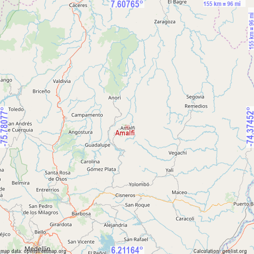
Amalfi GPS coordinates[2]
6° 54' 36.576" North, 75° 4' 39.504" West
| Map corner | latitude | longitude |
|---|---|---|
| Upper-left | 7.60765°, | -75.78077° |
| Center: | 6.91016°, | -75.07764° |
| Lower-right: | 6.21164°, | -74.37452° |
| Map W x H: | 155.2×155.2 km | = 96.4×96.4mi |
| max Lat: | 13.38166° ⇑26.4% North |
| Amalfi: | 6.91016° |
| min Lat: | ⇓73.6% South -4.21528° |
| min Long | Amalfi | max Long |
| -81.70636° | -75.07764° | -67.06996° |
| W 44.2%⇐ | ⇒55.8% E |
Elevation
Elevation of Amalfi is 1544 m = 5066 ft, and this is 394.7 m = 1295 ft above average elevation for this country.
| Max E: |
3342 m = 10965 ft | 37.1% |
| Amalfi | 1544 m 5066 ft | |
| Avg. | 1149.3 m = 3771 ft | |
Min E: |
1 m = 3 ft | 62.9% |
See also: Colombia elevation on elevation.city.
Geographical zone
Amalfi is located in North Torrid zone (between Equator and Tropic of Cancer). Distance of Equator is 768.3 km =477.4 mi to South.| Distance of | km | miles | from Amalfi |
|---|---|---|---|
| North Pole | 9238.7 | 5740.7 | to North |
| Arctic Circle | 6632.8 | 4121.4 | to North |
| Tropic Cancer | 1837.6 | 1141.8 | to North |
| Equator | 768.3 | 477.4 | to South |


Nearby cities:
15 places around Amalfi: (largest is in red/bold)
• Angostura
28.5 km =17.7 mi,  264°
264°
• Anorí
19.7 km =12.2 mi,  336°
336°
• Campamento
25.4 km =15.8 mi,  287°
287°
• Carolina
30.6 km =19 mi,  227°
227°
• Cisneros
41.4 km =25.7 mi,  181°
181°
• Cruces de Anorí
30.4 km =18.9 mi,  2°
2°
• Guadalupe
20.9 km =13 mi,  239°
239°
• Gómez Plata
29.8 km =18.5 mi,  211°
211°
• Remedios
44.4 km =27.6 mi,  72°
72°
• San Roque
47.7 km =29.6 mi,  172°
172°
• Segovia
45.9 km =28.5 mi, 65°
• Vegachí
35.3 km =21.9 mi,  117°
117°
• Yalí
37.5 km =23.3 mi,  134°
134°
• Yarumal
38 km =23.6 mi,  278°
278°
• Yolombó
35.4 km =22 mi, 168°
Sources, notices
• [Note1] Compared only with cities in Colombia existing in our database
• [Src1] Map data: © OpenStreetMap contributors (CC-BY-SA)
• [Src2] Other city data from geonames.org with taken over terms of usage.
• [Src3] Geographical zone / Annual Mean Temperature by Robert A. Rohde @ Wikipedia
