Villa Caro geodata
Villa Caro (Norte de Santander) is a seat of a second-order administrative division; located in Colombia in America/Bogota (GMT-5) time zone. In our database, there are 1053 cities with bigger population. Compared to other cities in Colombia, 80.2% of cities are located further ↓South; 87.2% of cities are located further ←West and 65.3% of cities have lower elevation than Villa Caro. Note1


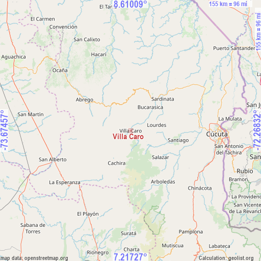
Villa Caro GPS coordinates[2]
7° 54' 51.372" North, 72° 58' 17.184" West
| Map corner | latitude | longitude |
|---|---|---|
| Upper-left | 8.61009°, | -73.67457° |
| Center: | 7.91427°, | -72.97144° |
| Lower-right: | 7.21727°, | -72.26832° |
| Map W x H: | 154.9×154.9 km | = 96.3×96.3mi |
| max Lat: | 13.38166° ⇑19.8% North |
| Villa Caro: | 7.91427° |
| min Lat: | ⇓80.2% South -4.21528° |
| min Long | Villa Caro | max Long |
| -81.70636° | -72.97144° | -67.06996° |
| W 87.2%⇐ | ⇒12.8% E |
Elevation
Elevation of Villa Caro is 1595 m = 5233 ft, and this is 445.7 m = 1462 ft above average elevation for this country.
| Max E: |
3342 m = 10965 ft | 34.7% |
| Villa Caro | 1595 m 5233 ft | |
| Avg. | 1149.3 m = 3771 ft | |
Min E: |
1 m = 3 ft | 65.3% |
See also: Colombia elevation on elevation.city.
Geographical zone
Villa Caro is located in North Torrid zone (between Equator and Tropic of Cancer). Distance of Equator is 880 km =546.8 mi to South.| Distance of | km | miles | from Villa Caro |
|---|---|---|---|
| North Pole | 9127.1 | 5671.3 | to North |
| Arctic Circle | 6521.2 | 4052.1 | to North |
| Tropic Cancer | 1725.9 | 1072.4 | to North |
| Equator | 880 | 546.8 | to South |


Nearby cities:
15 places around Villa Caro: (largest is in red/bold)
• Arboledas
35.7 km =22.2 mi,  147°
147°
• Bochalema
49.1 km =30.5 mi,  133°
133°
• Bucarasica
18.3 km =11.4 mi,  39°
39°
• Cucutilla
47.1 km =29.3 mi, 152°
• Cáchira
21 km =13 mi,  203°
203°
• Durania
41.2 km =25.6 mi,  122°
122°
• El Zulia
40.8 km =25.4 mi,  87°
87°
• Gramalote
19.4 km =12.1 mi,  98°
98°
• La Playa
44.4 km =27.6 mi,  318°
318°
• Lourdes
15.7 km =9.8 mi,  77°
77°
• San Alberto
49.4 km =30.7 mi,  249°
249°
• San Cayetano
38.5 km =23.9 mi, 96°
• Santiago
28.7 km =17.8 mi, 101°
• Sardinata
26.6 km =16.5 mi,  45°
45°
• Ábrego
33.1 km =20.6 mi,  303°
303°
Sources, notices
• [Note1] Compared only with cities in Colombia existing in our database
• [Src1] Map data: © OpenStreetMap contributors (CC-BY-SA)
• [Src2] Other city data from geonames.org with taken over terms of usage.
• [Src3] Geographical zone / Annual Mean Temperature by Robert A. Rohde @ Wikipedia
