Cáchira geodata
Cáchira (Norte de Santander) is a seat of a second-order administrative division; located in Colombia in America/Bogota (GMT-5) time zone. With population of 2,097 people, there are 787 cities with bigger population in this country. Compared to other cities in Colombia, 79.1% of cities are located further ↓South; 85.7% of cities are located further ←West and 79.2% of cities have lower elevation than Cáchira. Note1


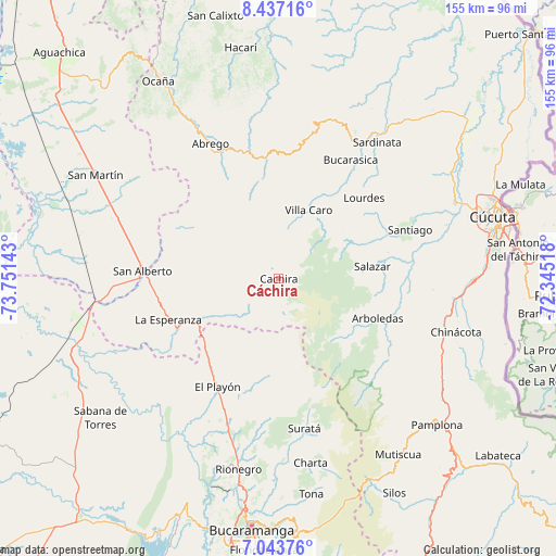
Cáchira GPS coordinates[2]
7° 44' 27.744" North, 73° 2' 53.88" West
| Map corner | latitude | longitude |
|---|---|---|
| Upper-left | 8.43716°, | -73.75143° |
| Center: | 7.74104°, | -73.0483° |
| Lower-right: | 7.04376°, | -72.34518° |
| Map W x H: | 154.9×154.9 km | = 96.3×96.3mi |
| max Lat: | 13.38166° ⇑20.9% North |
| Cáchira: | 7.74104° |
| min Lat: | ⇓79.1% South -4.21528° |
| min Long | Cáchira | max Long |
| -81.70636° | -73.0483° | -67.06996° |
| W 85.7%⇐ | ⇒14.3% E |
Elevation
Elevation of Cáchira is 2007 m = 6585 ft, and this is 857.7 m = 2814 ft above average elevation for this country.
| Max E: |
3342 m = 10965 ft | 20.8% |
| Cáchira | 2007 m 6585 ft | |
| Avg. | 1149.3 m = 3771 ft | |
Min E: |
1 m = 3 ft | 79.2% |
See also: Colombia elevation on elevation.city.
Geographical zone
Cáchira is located in North Torrid zone (between Equator and Tropic of Cancer). Distance of Equator is 860.7 km =534.8 mi to South.| Distance of | km | miles | from Cáchira |
|---|---|---|---|
| North Pole | 9146.3 | 5683.2 | to North |
| Arctic Circle | 6540.5 | 4064.1 | to North |
| Tropic Cancer | 1745.2 | 1084.4 | to North |
| Equator | 860.7 | 534.8 | to South |


Nearby cities:
15 places around Cáchira: (largest is in red/bold)
• Arboledas
29.5 km =18.3 mi,  111°
111°
• Bochalema
46.4 km =28.8 mi, 108°
• Bucarasica
39 km =24.2 mi,  31°
31°
• California
45.2 km =28.1 mi,  165°
165°
• Cucutilla
37.8 km =23.5 mi,  126°
126°
• Durania
43.2 km =26.8 mi,  94°
94°
• El Playón
34.5 km =21.4 mi,  209°
209°
• Gramalote
32.1 km =19.9 mi,  59°
59°
• La Esperanza
32.7 km =20.3 mi,  250°
250°
• Lourdes
32.8 km =20.4 mi,  46°
46°
• San Alberto
38 km =23.6 mi,  273°
273°
• Santiago
39.1 km =24.3 mi,  69°
69°
• Suratá
42.3 km =26.3 mi, 170°
• Villa Caro
21 km =13 mi,  23°
23°
• Ábrego
42.3 km =26.3 mi,  333°
333°
Sources, notices
• [Note1] Compared only with cities in Colombia existing in our database
• [Src1] Map data: © OpenStreetMap contributors (CC-BY-SA)
• [Src2] Other city data from geonames.org with taken over terms of usage.
• [Src3] Geographical zone / Annual Mean Temperature by Robert A. Rohde @ Wikipedia
