San Alberto geodata
San Alberto (Cesar) is a seat of a second-order administrative division; located in Colombia in America/Bogota (GMT-5) time zone. With population of 10,627 people, there are 292 cities with bigger population in this country. Compared to other cities in Colombia, 79.3% of cities are located further ↓South; 77.9% of cities are located further ←West and 79.9% of cities have higher elevation than San Alberto. Note1


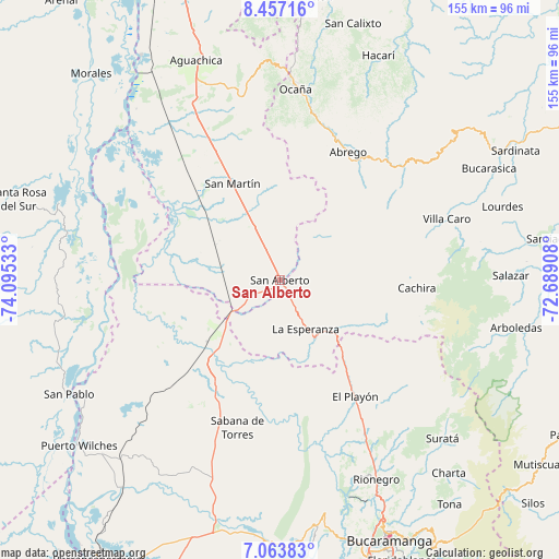
San Alberto GPS coordinates[2]
7° 45' 39.852" North, 73° 23' 31.92" West
| Map corner | latitude | longitude |
|---|---|---|
| Upper-left | 8.45716°, | -74.09533° |
| Center: | 7.76107°, | -73.3922° |
| Lower-right: | 7.06383°, | -72.68908° |
| Map W x H: | 154.9×154.9 km | = 96.3×96.3mi |
| max Lat: | 13.38166° ⇑20.7% North |
| San Alberto: | 7.76107° |
| min Lat: | ⇓79.3% South -4.21528° |
| min Long | San Alberto | max Long |
| -81.70636° | -73.3922° | -67.06996° |
| W 77.9%⇐ | ⇒22.1% E |
Elevation
Elevation of San Alberto is 118 m = 387 ft, and this is 1031.3 m = 3384 ft below average elevation for this country.
| Max E: |
3342 m = 10965 ft | 79.9% |
| Avg. | 1149.3 m = 3771 ft | |
| San Alberto | 118 m = 387 ft | |
Min E: |
1 m = 3 ft | 20.1% |
See also: Colombia elevation on elevation.city.
Geographical zone
San Alberto is located in North Torrid zone (between Equator and Tropic of Cancer). Distance of Equator is 863 km =536.2 mi to South.| Distance of | km | miles | from San Alberto |
|---|---|---|---|
| North Pole | 9144.1 | 5681.9 | to North |
| Arctic Circle | 6538.2 | 4062.6 | to North |
| Tropic Cancer | 1743 | 1083 | to North |
| Equator | 863 | 536.2 | to South |


Nearby cities:
15 places around San Alberto: (largest is in red/bold)
• Cáchira
38 km =23.6 mi,  93°
93°
• El Playón
38.4 km =23.9 mi,  147°
147°
• La Esperanza
15.2 km =9.4 mi, 152°
• La Playa
53.1 km =33 mi,  18°
18°
• Lourdes
64.9 km =40.3 mi,  71°
71°
• Matanza
64.1 km =39.8 mi,  139°
139°
• Ocaña
53.1 km =33 mi,  4°
4°
• Rionegro
61.3 km =38.1 mi, 154°
• Río de Oro
59 km =36.7 mi, 0°
• Sabana de Torres
42.6 km =26.5 mi,  195°
195°
• San Martín
29.8 km =18.5 mi,  333°
333°
• Simití
64.6 km =40.1 mi,  289°
289°
• Suratá
62.9 km =39.1 mi,  134°
134°
• Villa Caro
49.4 km =30.7 mi, 69°
• Ábrego
40.2 km =25 mi,  28°
28°
Sources, notices
• [Note1] Compared only with cities in Colombia existing in our database
• [Src1] Map data: © OpenStreetMap contributors (CC-BY-SA)
• [Src2] Other city data from geonames.org with taken over terms of usage.
• [Src3] Geographical zone / Annual Mean Temperature by Robert A. Rohde @ Wikipedia
