Bochalema geodata
Bochalema (Norte de Santander) is a seat of a second-order administrative division; located in Colombia in America/Bogota (GMT-5) time zone. With population of 2,511 people, there are 739 cities with bigger population in this country. Compared to other cities in Colombia, 78.7% of cities are located further ↓South; 93.5% of cities are located further ←West and 51.5% of cities have higher elevation than Bochalema. Note1


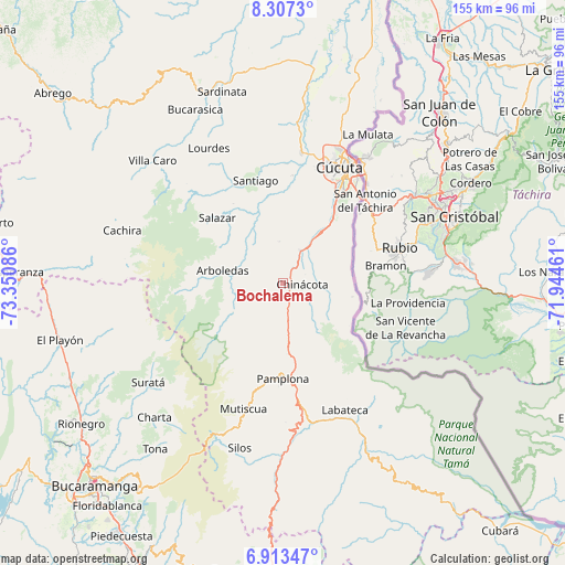
Bochalema GPS coordinates[2]
7° 36' 39.42" North, 72° 38' 51.828" West
| Map corner | latitude | longitude |
|---|---|---|
| Upper-left | 8.3073°, | -73.35086° |
| Center: | 7.61095°, | -72.64773° |
| Lower-right: | 6.91347°, | -71.94461° |
| Map W x H: | 155×155 km | = 96.3×96.3mi |
| max Lat: | 13.38166° ⇑21.3% North |
| Bochalema: | 7.61095° |
| min Lat: | ⇓78.7% South -4.21528° |
| min Long | Bochalema | max Long |
| -81.70636° | -72.64773° | -67.06996° |
| W 93.5%⇐ | ⇒6.5% E |
Elevation
Elevation of Bochalema is 1069 m = 3507 ft, and this is 80.3 m = 263 ft below average elevation for this country.
| Max E: |
3342 m = 10965 ft | 51.5% |
| Avg. | 1149.3 m = 3771 ft | |
| Bochalema | 1069 m = 3507 ft | |
Min E: |
1 m = 3 ft | 48.5% |
See also: Colombia elevation on elevation.city.
Geographical zone
Bochalema is located in North Torrid zone (between Equator and Tropic of Cancer). Distance of Equator is 846.3 km =525.9 mi to South.| Distance of | km | miles | from Bochalema |
|---|---|---|---|
| North Pole | 9160.8 | 5692.3 | to North |
| Arctic Circle | 6554.9 | 4073 | to North |
| Tropic Cancer | 1759.7 | 1093.4 | to North |
| Equator | 846.3 | 525.9 | to South |


Nearby cities:
15 places around Bochalema: (largest is in red/bold)
• Arboledas
17.1 km =10.6 mi,  281°
281°
• Chinácota
5.2 km =3.2 mi,  94°
94°
• Cucutilla
15.9 km =9.9 mi,  239°
239°
• Cúcuta
35 km =21.7 mi,  26°
26°
• Durania
11.4 km =7.1 mi,  354°
354°
• El Zulia
36.1 km =22.4 mi,  8°
8°
• Gramalote
34.9 km =21.7 mi,  331°
331°
• Herrán
21.5 km =13.4 mi,  122°
122°
• Los Patios
29.8 km =18.5 mi, 32°
• Pamplona
26.2 km =16.3 mi,  180°
180°
• Pamplonita
19.4 km =12.1 mi, 176°
• Ragonvalia
19.3 km =12 mi,  101°
101°
• San Cayetano
29.7 km =18.5 mi,  4°
4°
• Santiago
29.2 km =18.1 mi, 345°
• Villa del Rosario
31.3 km =19.4 mi,  37°
37°
Sources, notices
• [Note1] Compared only with cities in Colombia existing in our database
• [Src1] Map data: © OpenStreetMap contributors (CC-BY-SA)
• [Src2] Other city data from geonames.org with taken over terms of usage.
• [Src3] Geographical zone / Annual Mean Temperature by Robert A. Rohde @ Wikipedia
