Gramalote geodata
Gramalote (Norte de Santander) is a seat of a second-order administrative division; located in Colombia in America/Bogota (GMT-5) time zone. With population of 3,577 people, there are 622 cities with bigger population in this country. Compared to other cities in Colombia, 80% of cities are located further ↓South; 90.8% of cities are located further ←West and 52.5% of cities have higher elevation than Gramalote. Note1


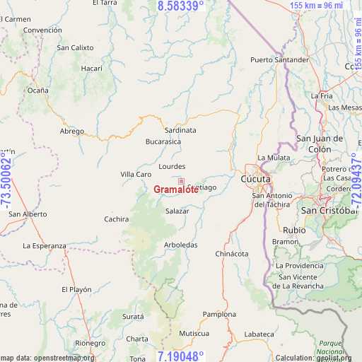
Gramalote GPS coordinates[2]
7° 53' 15.072" North, 72° 47' 50.964" West
| Map corner | latitude | longitude |
|---|---|---|
| Upper-left | 8.58339°, | -73.50062° |
| Center: | 7.88752°, | -72.79749° |
| Lower-right: | 7.19048°, | -72.09437° |
| Map W x H: | 154.9×154.9 km | = 96.3×96.3mi |
| max Lat: | 13.38166° ⇑20% North |
| Gramalote: | 7.88752° |
| min Lat: | ⇓80% South -4.21528° |
| min Long | Gramalote | max Long |
| -81.70636° | -72.79749° | -67.06996° |
| W 90.8%⇐ | ⇒9.2% E |
Elevation
Elevation of Gramalote is 1038 m = 3406 ft, and this is 111.3 m = 365 ft below average elevation for this country.
| Max E: |
3342 m = 10965 ft | 52.5% |
| Avg. | 1149.3 m = 3771 ft | |
| Gramalote | 1038 m = 3406 ft | |
Min E: |
1 m = 3 ft | 47.5% |
See also: Colombia elevation on elevation.city.
Geographical zone
Gramalote is located in North Torrid zone (between Equator and Tropic of Cancer). Distance of Equator is 877 km =544.9 mi to South.| Distance of | km | miles | from Gramalote |
|---|---|---|---|
| North Pole | 9130.1 | 5673.2 | to North |
| Arctic Circle | 6524.2 | 4053.9 | to North |
| Tropic Cancer | 1728.9 | 1074.3 | to North |
| Equator | 877 | 544.9 | to South |


Nearby cities:
15 places around Gramalote: (largest is in red/bold)
• Arboledas
27.3 km =17 mi,  180°
180°
• Bochalema
34.9 km =21.7 mi,  151°
151°
• Bucarasica
18.6 km =11.6 mi,  336°
336°
• Chinácota
37.9 km =23.5 mi, 145°
• Cáchira
32.1 km =19.9 mi,  239°
239°
• Cúcuta
31.9 km =19.8 mi,  88°
88°
• Durania
24.8 km =15.4 mi,  141°
141°
• El Zulia
22.2 km =13.8 mi,  76°
76°
• Los Patios
32.8 km =20.4 mi,  99°
99°
• Lourdes
7.4 km =4.6 mi,  328°
328°
• San Cayetano
19.1 km =11.9 mi, 93°
• Santiago
9.3 km =5.8 mi,  106°
106°
• Sardinata
21.7 km =13.5 mi,  359°
359°
• Villa Caro
19.4 km =12.1 mi,  278°
278°
• Villa del Rosario
36.1 km =22.4 mi, 99°
Sources, notices
• [Note1] Compared only with cities in Colombia existing in our database
• [Src1] Map data: © OpenStreetMap contributors (CC-BY-SA)
• [Src2] Other city data from geonames.org with taken over terms of usage.
• [Src3] Geographical zone / Annual Mean Temperature by Robert A. Rohde @ Wikipedia
