Venecia geodata
Venecia (Cundinamarca) is a seat of a second-order administrative division; located in Colombia in America/Bogota (GMT-5) time zone. With population of 1,307 people, there are 901 cities with bigger population in this country. Compared to other cities in Colombia, 77.3% of cities are located further ↑North; 57.1% of cities are located further ←West and 66.8% of cities have lower elevation than Venecia. Note1


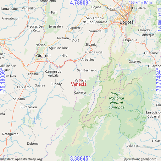
Venecia GPS coordinates[2]
4° 5' 17.088" North, 74° 28' 38.856" West
| Map corner | latitude | longitude |
|---|---|---|
| Upper-left | 4.78909°, | -75.18059° |
| Center: | 4.08808°, | -74.47746° |
| Lower-right: | 3.38645°, | -73.77434° |
| Map W x H: | 156×156 km | = 96.9×96.9mi |
| max Lat: | 13.38166° ⇑77.3% North |
| Venecia: | 4.08808° |
| min Lat: | ⇓22.7% South -4.21528° |
| min Long | Venecia | max Long |
| -81.70636° | -74.47746° | -67.06996° |
| W 57.1%⇐ | ⇒42.9% E |
Elevation
Elevation of Venecia is 1641 m = 5384 ft, and this is 491.7 m = 1613 ft above average elevation for this country.
| Max E: |
3342 m = 10965 ft | 33.2% |
| Venecia | 1641 m 5384 ft | |
| Avg. | 1149.3 m = 3771 ft | |
Min E: |
1 m = 3 ft | 66.8% |
See also: Colombia elevation on elevation.city.
Geographical zone
Venecia is located in North Torrid zone (between Equator and Tropic of Cancer). Distance of Equator is 454.6 km =282.5 mi to South.| Distance of | km | miles | from Venecia |
|---|---|---|---|
| North Pole | 9552.5 | 5935.6 | to North |
| Arctic Circle | 6946.6 | 4316.4 | to North |
| Tropic Cancer | 2151.4 | 1336.8 | to North |
| Equator | 454.6 | 282.5 | to South |


Nearby cities:
15 places around Venecia: (largest is in red/bold)
• Arbeláez
21.6 km =13.4 mi,  18°
18°
• Cabrera
11.4 km =7.1 mi,  183°
183°
• Carmen de Apicalá
27.7 km =17.2 mi,  283°
283°
• Cunday
24 km =14.9 mi,  262°
262°
• Fusagasugá
30.4 km =18.9 mi, 24°
• Icononzo
11.6 km =7.2 mi,  328°
328°
• Melgar
22.3 km =13.9 mi,  305°
305°
• Nilo
29 km =18 mi, 326°
• Pandi
11.5 km =7.1 mi,  354°
354°
• Pasca
31.3 km =19.4 mi,  38°
38°
• San Bernardo
11.7 km =7.3 mi,  30°
30°
• Silvania
36.5 km =22.7 mi, 16°
• Tibacuy
29.3 km =18.2 mi,  5°
5°
• Tres Esquinas
35.7 km =22.2 mi,  226°
226°
• Villarrica
21.8 km =13.5 mi,  218°
218°
Sources, notices
• [Note1] Compared only with cities in Colombia existing in our database
• [Src1] Map data: © OpenStreetMap contributors (CC-BY-SA)
• [Src2] Other city data from geonames.org with taken over terms of usage.
• [Src3] Geographical zone / Annual Mean Temperature by Robert A. Rohde @ Wikipedia
