Tres Esquinas geodata
Tres Esquinas (Tolima) is a populated place; located in Colombia in America/Bogota (GMT-5) time zone. With population of 1,181 people, there are 919 cities with bigger population in this country. Compared to other cities in Colombia, 79.1% of cities are located further ↑North; 53.2% of cities are located further ←West and 51.1% of cities have lower elevation than Tres Esquinas. Note1


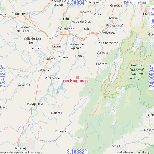
Tres Esquinas GPS coordinates[2]
3° 51' 54.432" North, 74° 42' 32.616" West
| Map corner | latitude | longitude |
|---|---|---|
| Upper-left | 4.56634°, | -75.41219° |
| Center: | 3.86512°, | -74.70906° |
| Lower-right: | 3.16332°, | -74.00594° |
| Map W x H: | 156×156 km | = 96.9×96.9mi |
| max Lat: | 13.38166° ⇑79.1% North |
| Tres Esquinas: | 3.86512° |
| min Lat: | ⇓20.9% South -4.21528° |
| min Long | Tres Esquinas | max Long |
| -81.70636° | -74.70906° | -67.06996° |
| W 53.2%⇐ | ⇒46.8% E |
Elevation
Elevation of Tres Esquinas is 1164 m = 3819 ft, and this is 14.7 m = 48 ft above average elevation for this country.
| Max E: |
3342 m = 10965 ft | 48.9% |
| Tres Esquinas | 1164 m 3819 ft | |
| Avg. | 1149.3 m = 3771 ft | |
Min E: |
1 m = 3 ft | 51.1% |
See also: Colombia elevation on elevation.city.
Geographical zone
Tres Esquinas is located in North Torrid zone (between Equator and Tropic of Cancer). Distance of Equator is 429.8 km =267.1 mi to South.| Distance of | km | miles | from Tres Esquinas |
|---|---|---|---|
| North Pole | 9577.3 | 5951.1 | to North |
| Arctic Circle | 6971.4 | 4331.8 | to North |
| Tropic Cancer | 2176.2 | 1352.2 | to North |
| Equator | 429.8 | 267.1 | to South |


Nearby cities:
15 places around Tres Esquinas: (largest is in red/bold)
• Cabrera
28.5 km =17.7 mi,  61°
61°
• Carmen de Apicalá
31.4 km =19.5 mi,  357°
357°
• Cunday
21.8 km =13.5 mi,  4°
4°
• Dolores
41.8 km =26 mi,  209°
209°
• Espinal
37.1 km =23.1 mi,  328°
328°
• Guamo
34.3 km =21.3 mi,  302°
302°
• Icononzo
39.8 km =24.7 mi,  29°
29°
• La Chamba
25.2 km =15.7 mi,  315°
315°
• Melgar
38.5 km =23.9 mi,  11°
11°
• Prado
27.6 km =17.1 mi,  242°
242°
• Purificación
24.7 km =15.3 mi,  268°
268°
• Saldaña
34.7 km =21.6 mi,  281°
281°
• Suárez
24.6 km =15.3 mi, 326°
• Venecia
35.7 km =22.2 mi,  46°
46°
• Villarrica
14.3 km =8.9 mi, 57°
Sources, notices
• [Note1] Compared only with cities in Colombia existing in our database
• [Src1] Map data: © OpenStreetMap contributors (CC-BY-SA)
• [Src2] Other city data from geonames.org with taken over terms of usage.
• [Src3] Geographical zone / Annual Mean Temperature by Robert A. Rohde @ Wikipedia
