Cunday geodata
Cunday (Tolima) is a seat of a second-order administrative division; located in Colombia in America/Bogota (GMT-5) time zone. With population of 2,082 people, there are 790 cities with bigger population in this country. Compared to other cities in Colombia, 77.5% of cities are located further ↑North; 53.7% of cities are located further ←West and 64.6% of cities have higher elevation than Cunday. Note1


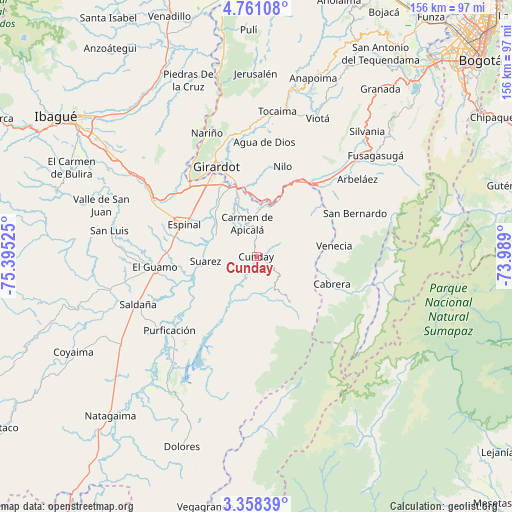
Cunday GPS coordinates[2]
4° 3' 36.144" North, 74° 41' 31.632" West
| Map corner | latitude | longitude |
|---|---|---|
| Upper-left | 4.76108°, | -75.39525° |
| Center: | 4.06004°, | -74.69212° |
| Lower-right: | 3.35839°, | -73.989° |
| Map W x H: | 156×156 km | = 96.9×96.9mi |
| max Lat: | 13.38166° ⇑77.5% North |
| Cunday: | 4.06004° |
| min Lat: | ⇓22.5% South -4.21528° |
| min Long | Cunday | max Long |
| -81.70636° | -74.69212° | -67.06996° |
| W 53.7%⇐ | ⇒46.3% E |
Elevation
Elevation of Cunday is 457 m = 1499 ft, and this is 692.3 m = 2271 ft below average elevation for this country.
| Max E: |
3342 m = 10965 ft | 64.6% |
| Avg. | 1149.3 m = 3771 ft | |
| Cunday | 457 m = 1499 ft | |
Min E: |
1 m = 3 ft | 35.4% |
See also: Colombia elevation on elevation.city.
Geographical zone
Cunday is located in North Torrid zone (between Equator and Tropic of Cancer). Distance of Equator is 451.4 km =280.5 mi to South.| Distance of | km | miles | from Cunday |
|---|---|---|---|
| North Pole | 9555.6 | 5937.6 | to North |
| Arctic Circle | 6949.7 | 4318.3 | to North |
| Tropic Cancer | 2154.5 | 1338.7 | to North |
| Equator | 451.4 | 280.5 | to South |


Nearby cities:
15 places around Cunday: (largest is in red/bold)
• Cabrera
24.6 km =15.3 mi,  109°
109°
• Carmen de Apicalá
10.2 km =6.3 mi,  342°
342°
• Espinal
23.5 km =14.6 mi,  294°
294°
• Flandes
29 km =18 mi,  331°
331°
• Girardot City
29.7 km =18.5 mi, 334°
• Icononzo
22 km =13.7 mi,  53°
53°
• La Chamba
19.9 km =12.4 mi,  259°
259°
• Melgar
17.1 km =10.6 mi,  19°
19°
• Nilo
28.5 km =17.7 mi, 16°
• Pandi
27 km =16.8 mi,  57°
57°
• Ricaurte
25.8 km =16 mi, 341°
• Suárez
15.6 km =9.7 mi,  265°
265°
• Tres Esquinas
21.8 km =13.5 mi,  184°
184°
• Venecia
24 km =14.9 mi,  82°
82°
• Villarrica
17.2 km =10.7 mi,  143°
143°
Sources, notices
• [Note1] Compared only with cities in Colombia existing in our database
• [Src1] Map data: © OpenStreetMap contributors (CC-BY-SA)
• [Src2] Other city data from geonames.org with taken over terms of usage.
• [Src3] Geographical zone / Annual Mean Temperature by Robert A. Rohde @ Wikipedia
