Melgar geodata
Melgar (Tolima) is a seat of a second-order administrative division; located in Colombia in America/Bogota (GMT-5) time zone. With population of 25,980 people, there are 142 cities with bigger population in this country. Compared to other cities in Colombia, 76.3% of cities are located further ↑North; 54.1% of cities are located further ←West and 68.4% of cities have higher elevation than Melgar. Note1


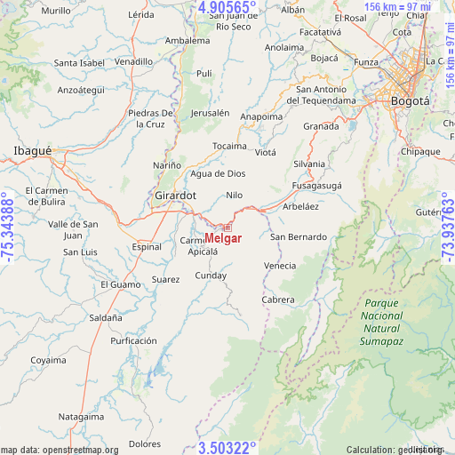
Melgar GPS coordinates[2]
4° 12' 17.1" North, 74° 38' 26.7" West
| Map corner | latitude | longitude |
|---|---|---|
| Upper-left | 4.90565°, | -75.34388° |
| Center: | 4.20475°, | -74.64075° |
| Lower-right: | 3.50322°, | -73.93763° |
| Map W x H: | 155.9×155.9 km | = 96.9×96.9mi |
| max Lat: | 13.38166° ⇑76.3% North |
| Melgar: | 4.20475° |
| min Lat: | ⇓23.7% South -4.21528° |
| min Long | Melgar | max Long |
| -81.70636° | -74.64075° | -67.06996° |
| W 54.1%⇐ | ⇒45.9% E |
Elevation
Elevation of Melgar is 325 m = 1066 ft, and this is 824.3 m = 2704 ft below average elevation for this country.
| Max E: |
3342 m = 10965 ft | 68.4% |
| Avg. | 1149.3 m = 3771 ft | |
| Melgar | 325 m = 1066 ft | |
Min E: |
1 m = 3 ft | 31.6% |
See also: Colombia elevation on elevation.city.
Geographical zone
Melgar is located in North Torrid zone (between Equator and Tropic of Cancer). Distance of Equator is 467.5 km =290.5 mi to South.| Distance of | km | miles | from Melgar |
|---|---|---|---|
| North Pole | 9539.5 | 5927.6 | to North |
| Arctic Circle | 6933.6 | 4308.3 | to North |
| Tropic Cancer | 2138.4 | 1328.7 | to North |
| Equator | 467.5 | 290.5 | to South |


Nearby cities:
15 places around Melgar: (largest is in red/bold)
• Agua de Dios
19.4 km =12.1 mi,  350°
350°
• Arbeláez
26.1 km =16.2 mi,  73°
73°
• Carmen de Apicalá
10.9 km =6.8 mi,  234°
234°
• Cunday
17.1 km =10.6 mi,  199°
199°
• Espinal
27.7 km =17.2 mi,  257°
257°
• Flandes
21.6 km =13.4 mi,  296°
296°
• Girardot City
21.4 km =13.3 mi, 300°
• Icononzo
12.4 km =7.7 mi,  104°
104°
• Nilo
11.5 km =7.1 mi,  11°
11°
• Pandi
17.1 km =10.6 mi, 95°
• Ricaurte
16.1 km =10 mi, 301°
• San Bernardo
24.3 km =15.1 mi, 96°
• Suárez
27.4 km =17 mi, 230°
• Tibacuy
26.5 km =16.5 mi,  52°
52°
• Venecia
22.3 km =13.9 mi,  125°
125°
Sources, notices
• [Note1] Compared only with cities in Colombia existing in our database
• [Src1] Map data: © OpenStreetMap contributors (CC-BY-SA)
• [Src2] Other city data from geonames.org with taken over terms of usage.
• [Src3] Geographical zone / Annual Mean Temperature by Robert A. Rohde @ Wikipedia
