Suratá geodata
Suratá (Santander) is a seat of a second-order administrative division; located in Colombia in America/Bogota (GMT-5) time zone. With population of 806 people, there are 979 cities with bigger population in this country. Compared to other cities in Colombia, 77.3% of cities are located further ↓South; 86.7% of cities are located further ←West and 70.7% of cities have lower elevation than Suratá. Note1


Suratá GPS coordinates[2]
7° 21' 58.788" North, 72° 59' 0.996" West
| Map corner | latitude | longitude |
|---|---|---|
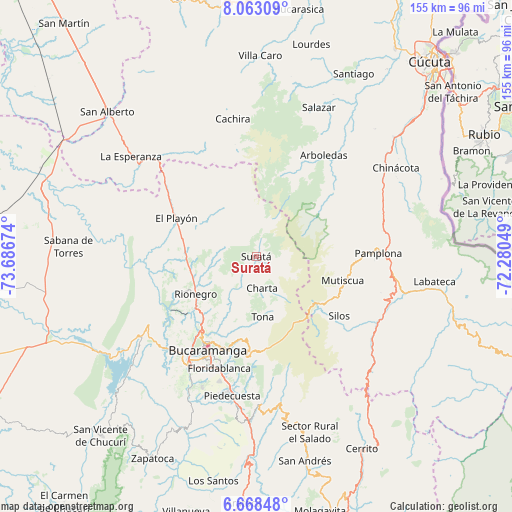
| Upper-left | 8.06309°, | -73.68674° |
| Center: | 7.36633°, | -72.98361° |
| Lower-right: | 6.66848°, | -72.28049° |
| Map W x H: | 155.1×155.1 km | = 96.4×96.4mi |
| max Lat: | 13.38166° ⇑22.7% North |
| Suratá: | 7.36633° |
| min Lat: | ⇓77.3% South -4.21528° |
| min Long | Suratá | max Long |
| -81.70636° | -72.98361° | -67.06996° |
| W 86.7%⇐ | ⇒13.3% E |
Elevation
Elevation of Suratá is 1748 m = 5735 ft, and this is 598.7 m = 1964 ft above average elevation for this country.
| Max E: |
3342 m = 10965 ft | 29.3% |
| Suratá | 1748 m 5735 ft | |
| Avg. | 1149.3 m = 3771 ft | |
Min E: |
1 m = 3 ft | 70.7% |
See also: Colombia elevation on elevation.city.
Geographical zone
Suratá is located in North Torrid zone (between Equator and Tropic of Cancer). Distance of Equator is 819.1 km =509 mi to South.| Distance of | km | miles | from Suratá |
|---|---|---|---|
| North Pole | 9188 | 5709.2 | to North |
| Arctic Circle | 6582.1 | 4089.9 | to North |
| Tropic Cancer | 1786.9 | 1110.3 | to North |
| Equator | 819.1 | 509 | to South |


Nearby cities:
15 places around Suratá: (largest is in red/bold)
• Arboledas
36.8 km =22.9 mi,  33°
33°
• Bucaramanga
30.7 km =19.1 mi,  209°
209°
• California
4.7 km =2.9 mi,  116°
116°
• Charta
9.7 km =6 mi,  169°
169°
• Cucutilla
30.2 km =18.8 mi,  50°
50°
• El Playón
26.9 km =16.7 mi,  295°
295°
• Floridablanca
35.7 km =22.2 mi,  198°
198°
• Los Santos
24.9 km =15.5 mi, 208°
• Matanza
6 km =3.7 mi,  215°
215°
• Mutiscua
27.1 km =16.8 mi,  105°
105°
• Pamplona
37 km =23 mi,  88°
88°
• Rionegro
21.6 km =13.4 mi,  238°
238°
• Silos
30.8 km =19.1 mi,  125°
125°
• Tona
18.4 km =11.4 mi, 173°
• Vetas
13.9 km =8.6 mi, 117°
Sources, notices
• [Note1] Compared only with cities in Colombia existing in our database
• [Src1] Map data: © OpenStreetMap contributors (CC-BY-SA)
• [Src2] Other city data from geonames.org with taken over terms of usage.
• [Src3] Geographical zone / Annual Mean Temperature by Robert A. Rohde @ Wikipedia
