Los Santos geodata
Los Santos (Santander) is a populated place; located in Colombia in America/Bogota (GMT-5) time zone. With population of 1,310 people, there are 900 cities with bigger population in this country. Compared to other cities in Colombia, 75.9% of cities are located further ↓South; 85% of cities are located further ←West and 51.7% of cities have higher elevation than Los Santos. Note1


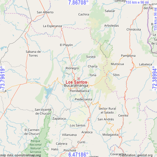
Los Santos GPS coordinates[2]
7° 10' 12" North, 73° 5' 35.016" West
| Map corner | latitude | longitude |
|---|---|---|
| Upper-left | 7.86708°, | -73.79619° |
| Center: | 7.17°, | -73.09306° |
| Lower-right: | 6.47186°, | -72.38994° |
| Map W x H: | 155.1×155.1 km | = 96.4×96.4mi |
| max Lat: | 13.38166° ⇑24.1% North |
| Los Santos: | 7.17° |
| min Lat: | ⇓75.9% South -4.21528° |
| min Long | Los Santos | max Long |
| -81.70636° | -73.09306° | -67.06996° |
| W 85%⇐ | ⇒15% E |
Elevation
Elevation of Los Santos is 1062 m = 3484 ft, and this is 87.3 m = 286 ft below average elevation for this country.
| Max E: |
3342 m = 10965 ft | 51.7% |
| Avg. | 1149.3 m = 3771 ft | |
| Los Santos | 1062 m = 3484 ft | |
Min E: |
1 m = 3 ft | 48.3% |
See also: Colombia elevation on elevation.city.
Geographical zone
Los Santos is located in North Torrid zone (between Equator and Tropic of Cancer). Distance of Equator is 797.2 km =495.4 mi to South.| Distance of | km | miles | from Los Santos |
|---|---|---|---|
| North Pole | 9209.8 | 5722.7 | to North |
| Arctic Circle | 6603.9 | 4103.5 | to North |
| Tropic Cancer | 1808.7 | 1123.9 | to North |
| Equator | 797.2 | 495.4 | to South |


Nearby cities:
15 places around Los Santos: (largest is in red/bold)
• Betulia
36.6 km =22.7 mi,  215°
215°
• Bucaramanga
5.8 km =3.6 mi,  210°
210°
• California
25.6 km =15.9 mi,  39°
39°
• Charta
18.5 km =11.5 mi,  48°
48°
• El Playón
35.6 km =22.1 mi,  340°
340°
• Floridablanca
12 km =7.5 mi,  176°
176°
• Girón
14.1 km =8.8 mi, 216°
• Lebrija
15.1 km =9.4 mi,  245°
245°
• Matanza
19 km =11.8 mi,  26°
26°
• Piedecuesta
20.8 km =12.9 mi,  166°
166°
• Rionegro
12.3 km =7.6 mi,  329°
329°
• Santa Bárbara
28.7 km =17.8 mi,  134°
134°
• Suratá
24.9 km =15.5 mi, 28°
• Tona
14.6 km =9.1 mi,  75°
75°
• Vetas
28.9 km =18 mi,  57°
57°
Sources, notices
• [Note1] Compared only with cities in Colombia existing in our database
• [Src1] Map data: © OpenStreetMap contributors (CC-BY-SA)
• [Src2] Other city data from geonames.org with taken over terms of usage.
• [Src3] Geographical zone / Annual Mean Temperature by Robert A. Rohde @ Wikipedia
