El Playón geodata
El Playón (Santander) is a seat of a second-order administrative division; located in Colombia in America/Bogota (GMT-5) time zone. With population of 5,334 people, there are 488 cities with bigger population in this country. Compared to other cities in Colombia, 77.8% of cities are located further ↓South; 82.9% of cities are located further ←West and 65% of cities have higher elevation than El Playón. Note1


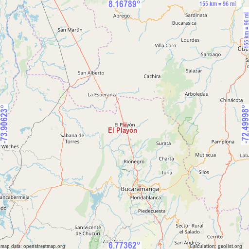
El Playón GPS coordinates[2]
7° 28' 16.716" North, 73° 12' 11.16" West
| Map corner | latitude | longitude |
|---|---|---|
| Upper-left | 8.16789°, | -73.90623° |
| Center: | 7.47131°, | -73.2031° |
| Lower-right: | 6.77362°, | -72.49998° |
| Map W x H: | 155×155 km | = 96.3×96.3mi |
| max Lat: | 13.38166° ⇑22.2% North |
| El Playón: | 7.47131° |
| min Lat: | ⇓77.8% South -4.21528° |
| min Long | El Playón | max Long |
| -81.70636° | -73.2031° | -67.06996° |
| W 82.9%⇐ | ⇒17.1% E |
Elevation
Elevation of El Playón is 439 m = 1440 ft, and this is 710.3 m = 2330 ft below average elevation for this country.
| Max E: |
3342 m = 10965 ft | 65% |
| Avg. | 1149.3 m = 3771 ft | |
| El Playón | 439 m = 1440 ft | |
Min E: |
1 m = 3 ft | 35% |
See also: Colombia elevation on elevation.city.
Geographical zone
El Playón is located in North Torrid zone (between Equator and Tropic of Cancer). Distance of Equator is 830.7 km =516.2 mi to South.| Distance of | km | miles | from El Playón |
|---|---|---|---|
| North Pole | 9176.3 | 5701.9 | to North |
| Arctic Circle | 6570.4 | 4082.7 | to North |
| Tropic Cancer | 1775.2 | 1103.1 | to North |
| Equator | 830.7 | 516.2 | to South |


Nearby cities:
15 places around El Playón: (largest is in red/bold)
• Bucaramanga
39.5 km =24.5 mi,  166°
166°
• California
31.5 km =19.6 mi,  115°
115°
• Charta
33.5 km =20.8 mi,  129°
129°
• Cáchira
34.5 km =21.4 mi,  29°
29°
• Girón
45 km =28 mi,  175°
175°
• La Esperanza
23.3 km =14.5 mi,  323°
323°
• Lebrija
39.9 km =24.8 mi, 182°
• Los Santos
35.6 km =22.1 mi,  160°
160°
• Matanza
26.5 km =16.5 mi, 128°
• Rionegro
23.7 km =14.7 mi, 165°
• Sabana de Torres
33.5 km =20.8 mi,  254°
254°
• San Alberto
38.4 km =23.9 mi,  327°
327°
• Suratá
26.9 km =16.7 mi, 115°
• Tona
39.8 km =24.7 mi,  138°
138°
• Vetas
40.8 km =25.4 mi, 116°
Sources, notices
• [Note1] Compared only with cities in Colombia existing in our database
• [Src1] Map data: © OpenStreetMap contributors (CC-BY-SA)
• [Src2] Other city data from geonames.org with taken over terms of usage.
• [Src3] Geographical zone / Annual Mean Temperature by Robert A. Rohde @ Wikipedia
