Bucaramanga geodata
Bucaramanga (Santander) is a seat of a first-order administrative division; located in Colombia in America/Bogota (GMT-5) time zone. With population of 571,820 people, there are 6 cities with bigger population in this country. Compared to other cities in Colombia, 75.5% of cities are located further ↓South; 84.4% of cities are located further ←West and 53.7% of cities have higher elevation than Bucaramanga. Note1


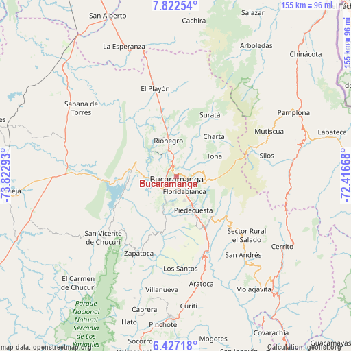
Bucaramanga GPS coordinates[2]
7° 7' 31.404" North, 73° 7' 11.28" West
| Map corner | latitude | longitude |
|---|---|---|
| Upper-left | 7.82254°, | -73.82293° |
| Center: | 7.12539°, | -73.1198° |
| Lower-right: | 6.42718°, | -72.41668° |
| Map W x H: | 155.1×155.2 km | = 96.4×96.4mi |
| max Lat: | 13.38166° ⇑24.5% North |
| Bucaramanga: | 7.12539° |
| min Lat: | ⇓75.5% South -4.21528° |
| min Long | Bucaramanga | max Long |
| -81.70636° | -73.1198° | -67.06996° |
| W 84.4%⇐ | ⇒15.6% E |
Elevation
Elevation of Bucaramanga is 993 m = 3258 ft, and this is 156.3 m = 513 ft below average elevation for this country.
| Max E: |
3342 m = 10965 ft | 53.7% |
| Avg. | 1149.3 m = 3771 ft | |
| Bucaramanga | 993 m = 3258 ft | |
Min E: |
1 m = 3 ft | 46.3% |
See also: Bucaramanga elevation on elevation.city.
Geographical zone
Bucaramanga is located in North Torrid zone (between Equator and Tropic of Cancer). Distance of Equator is 792.3 km =492.3 mi to South.| Distance of | km | miles | from Bucaramanga |
|---|---|---|---|
| North Pole | 9214.8 | 5725.8 | to North |
| Arctic Circle | 6608.9 | 4106.6 | to North |
| Tropic Cancer | 1813.6 | 1126.9 | to North |
| Equator | 792.3 | 492.3 | to South |


Nearby cities:
15 places around Bucaramanga: (largest is in red/bold)
• Betulia
30.8 km =19.1 mi,  215°
215°
• California
31.3 km =19.4 mi,  37°
37°
• Charta
24 km =14.9 mi, 44°
• Floridablanca
7.9 km =4.9 mi,  152°
152°
• Girón
8.4 km =5.2 mi, 220°
• Lebrija
10.9 km =6.8 mi,  262°
262°
• Los Santos
5.8 km =3.6 mi,  30°
30°
• Matanza
24.8 km =15.4 mi, 27°
• Piedecuesta
17.1 km =10.6 mi, 153°
• Rionegro
15.8 km =9.8 mi,  347°
347°
• Santa Bárbara
27.9 km =17.3 mi,  122°
122°
• Suratá
30.7 km =19.1 mi, 29°
• Tona
19.1 km =11.9 mi,  63°
63°
• Vetas
34.2 km =21.3 mi,  53°
53°
• Zapatoca
38.1 km =23.7 mi,  205°
205°
Sources, notices
• [Note1] Compared only with cities in Colombia existing in our database
• [Src1] Map data: © OpenStreetMap contributors (CC-BY-SA)
• [Src2] Other city data from geonames.org with taken over terms of usage.
• [Src3] Geographical zone / Annual Mean Temperature by Robert A. Rohde @ Wikipedia
