Mutiscua geodata
Mutiscua (Norte de Santander) is a seat of a second-order administrative division; located in Colombia in America/Bogota (GMT-5) time zone. With population of 918 people, there are 960 cities with bigger population in this country. Compared to other cities in Colombia, 76.8% of cities are located further ↓South; 91.6% of cities are located further ←West and 93.5% of cities have lower elevation than Mutiscua. Note1


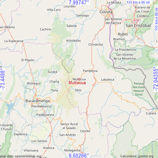
Mutiscua GPS coordinates[2]
7° 18' 2.196" North, 72° 44' 48.012" West
| Map corner | latitude | longitude |
|---|---|---|
| Upper-left | 7.99747°, | -73.4498° |
| Center: | 7.30061°, | -72.74667° |
| Lower-right: | 6.60266°, | -72.04355° |
| Map W x H: | 155.1×155.1 km | = 96.4×96.4mi |
| max Lat: | 13.38166° ⇑23.2% North |
| Mutiscua: | 7.30061° |
| min Lat: | ⇓76.8% South -4.21528° |
| min Long | Mutiscua | max Long |
| -81.70636° | -72.74667° | -67.06996° |
| W 91.6%⇐ | ⇒8.4% E |
Elevation
Elevation of Mutiscua is 2609 m = 8560 ft, and this is 1459.7 m = 4789 ft above average elevation for this country.
| Max E: |
3342 m = 10965 ft | 6.5% |
| Mutiscua | 2609 m 8560 ft | |
| Avg. | 1149.3 m = 3771 ft | |
Min E: |
1 m = 3 ft | 93.5% |
See also: Colombia elevation on elevation.city.
Geographical zone
Mutiscua is located in North Torrid zone (between Equator and Tropic of Cancer). Distance of Equator is 811.8 km =504.4 mi to South.| Distance of | km | miles | from Mutiscua |
|---|---|---|---|
| North Pole | 9195.3 | 5713.7 | to North |
| Arctic Circle | 6589.4 | 4094.5 | to North |
| Tropic Cancer | 1794.2 | 1114.9 | to North |
| Equator | 811.8 | 504.4 | to South |


Nearby cities:
15 places around Mutiscua: (largest is in red/bold)
• Bochalema
36.2 km =22.5 mi,  17°
17°
• California
22.6 km =14 mi,  283°
283°
• Charta
24.5 km =15.2 mi,  264°
264°
• Chitagá
20.2 km =12.6 mi,  153°
153°
• Cucutilla
26.7 km =16.6 mi,  353°
353°
• Cácota
12.1 km =7.5 mi,  107°
107°
• Labateca
27.8 km =17.3 mi,  90°
90°
• Matanza
29.7 km =18.5 mi,  274°
274°
• Pamplona
13.7 km =8.5 mi,  52°
52°
• Pamplonita
19.3 km =12 mi,  38°
38°
• Silos
10.7 km =6.6 mi,  185°
185°
• Suratá
27.1 km =16.8 mi,  285°
285°
• Toledo
29.1 km =18.1 mi, 87°
• Tona
26.5 km =16.5 mi,  245°
245°
• Vetas
13.8 km =8.6 mi, 273°
Sources, notices
• [Note1] Compared only with cities in Colombia existing in our database
• [Src1] Map data: © OpenStreetMap contributors (CC-BY-SA)
• [Src2] Other city data from geonames.org with taken over terms of usage.
• [Src3] Geographical zone / Annual Mean Temperature by Robert A. Rohde @ Wikipedia
