Charta geodata
Charta (Santander) is a seat of a second-order administrative division; located in Colombia in America/Bogota (GMT-5) time zone. With population of 650 people, there are 1008 cities with bigger population in this country. Compared to other cities in Colombia, 76.6% of cities are located further ↓South; 87.3% of cities are located further ←West and 79% of cities have lower elevation than Charta. Note1


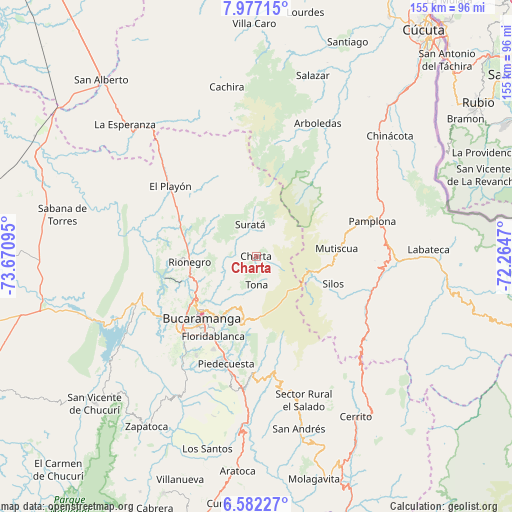
Charta GPS coordinates[2]
7° 16' 48.9" North, 72° 58' 4.152" West
| Map corner | latitude | longitude |
|---|---|---|
| Upper-left | 7.97715°, | -73.67095° |
| Center: | 7.28025°, | -72.96782° |
| Lower-right: | 6.58227°, | -72.2647° |
| Map W x H: | 155.1×155.1 km | = 96.4×96.4mi |
| max Lat: | 13.38166° ⇑23.4% North |
| Charta: | 7.28025° |
| min Lat: | ⇓76.6% South -4.21528° |
| min Long | Charta | max Long |
| -81.70636° | -72.96782° | -67.06996° |
| W 87.3%⇐ | ⇒12.7% E |
Elevation
Elevation of Charta is 2000 m = 6562 ft, and this is 850.7 m = 2791 ft above average elevation for this country.
| Max E: |
3342 m = 10965 ft | 21% |
| Charta | 2000 m 6562 ft | |
| Avg. | 1149.3 m = 3771 ft | |
Min E: |
1 m = 3 ft | 79% |
See also: Colombia elevation on elevation.city.
Geographical zone
Charta is located in North Torrid zone (between Equator and Tropic of Cancer). Distance of Equator is 809.5 km =503 mi to South.| Distance of | km | miles | from Charta |
|---|---|---|---|
| North Pole | 9197.6 | 5715.1 | to North |
| Arctic Circle | 6591.7 | 4095.9 | to North |
| Tropic Cancer | 1796.4 | 1116.2 | to North |
| Equator | 809.5 | 503 | to South |


Nearby cities:
15 places around Charta: (largest is in red/bold)
• Bucaramanga
24 km =14.9 mi,  224°
224°
• California
7.9 km =4.9 mi,  17°
17°
• El Playón
33.5 km =20.8 mi,  309°
309°
• Floridablanca
27.5 km =17.1 mi,  208°
208°
• Girón
32.4 km =20.1 mi, 223°
• Lebrija
33.3 km =20.7 mi,  236°
236°
• Los Santos
18.5 km =11.5 mi,  228°
228°
• Matanza
7 km =4.3 mi, 311°
• Mutiscua
24.5 km =15.2 mi,  84°
84°
• Rionegro
20.2 km =12.6 mi,  265°
265°
• Santa Bárbara
32.9 km =20.4 mi,  168°
168°
• Silos
24.8 km =15.4 mi,  109°
109°
• Suratá
9.7 km =6 mi,  349°
349°
• Tona
8.7 km =5.4 mi,  177°
177°
• Vetas
11.1 km =6.9 mi,  73°
73°
Sources, notices
• [Note1] Compared only with cities in Colombia existing in our database
• [Src1] Map data: © OpenStreetMap contributors (CC-BY-SA)
• [Src2] Other city data from geonames.org with taken over terms of usage.
• [Src3] Geographical zone / Annual Mean Temperature by Robert A. Rohde @ Wikipedia
