Isnos geodata
Isnos (Huila) is a seat of a second-order administrative division; located in Colombia in America/Bogota (GMT-5) time zone. In our database, there are 1053 cities with bigger population. Compared to other cities in Colombia, 90.7% of cities are located further ↑North; 83% of cities are located further →East and 71.5% of cities have lower elevation than Isnos. Note1


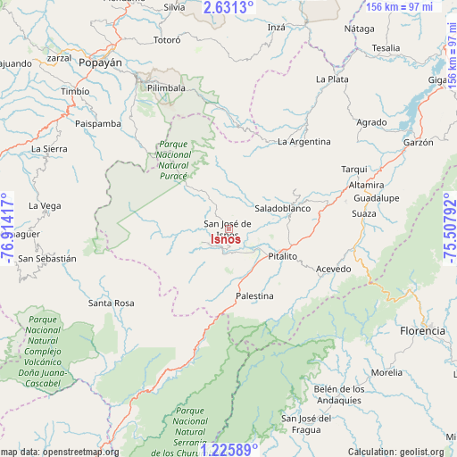
Isnos GPS coordinates[2]
1° 55' 43.464" North, 76° 12' 39.744" West
| Map corner | latitude | longitude |
|---|---|---|
| Upper-left | 2.6313°, | -76.91417° |
| Center: | 1.92874°, | -76.21104° |
| Lower-right: | 1.22589°, | -75.50792° |
| Map W x H: | 156.3×156.3 km | = 97.1×97.1mi |
| max Lat: | 13.38166° ⇑90.7% North |
| Isnos: | 1.92874° |
| min Lat: | ⇓9.3% South -4.21528° |
| min Long | Isnos | max Long |
| -81.70636° | -76.21104° | -67.06996° |
| W 17%⇐ | ⇒83% E |
Elevation
Elevation of Isnos is 1766 m = 5794 ft, and this is 616.7 m = 2023 ft above average elevation for this country.
| Max E: |
3342 m = 10965 ft | 28.5% |
| Isnos | 1766 m 5794 ft | |
| Avg. | 1149.3 m = 3771 ft | |
Min E: |
1 m = 3 ft | 71.5% |
See also: Colombia elevation on elevation.city.
Geographical zone
Isnos is located in North Torrid zone (between Equator and Tropic of Cancer). Distance of Equator is 214.5 km =133.3 mi to South.| Distance of | km | miles | from Isnos |
|---|---|---|---|
| North Pole | 9792.6 | 6084.8 | to North |
| Arctic Circle | 7186.7 | 4465.6 | to North |
| Tropic Cancer | 2391.5 | 1486 | to North |
| Equator | 214.5 | 133.3 | to South |


Nearby cities:
15 places around Isnos: (largest is in red/bold)
• Acevedo
38.2 km =23.7 mi,  111°
111°
• Altamira
49.4 km =30.7 mi,  72°
72°
• Elías
31.5 km =19.6 mi, 72°
• Guadalupe
51.7 km =32.1 mi,  78°
78°
• Isnos
3.4 km =2.1 mi,  283°
283°
• La Argentina
39.4 km =24.5 mi,  40°
40°
• Oporapa
26.1 km =16.2 mi, 66°
• Palestina
24.4 km =15.2 mi,  159°
159°
• Pitalito
19.7 km =12.2 mi,  115°
115°
• Saladoblanco
19.9 km =12.4 mi, 69°
• San Agustín
8.4 km =5.2 mi,  228°
228°
• Santa Rosa
47.5 km =29.5 mi,  238°
238°
• Suaza
46.6 km =29 mi, 83°
• Tarqui
47.6 km =29.6 mi,  64°
64°
• Timaná
31.5 km =19.6 mi, 81°
Sources, notices
• [Note1] Compared only with cities in Colombia existing in our database
• [Src1] Map data: © OpenStreetMap contributors (CC-BY-SA)
• [Src2] Other city data from geonames.org with taken over terms of usage.
• [Src3] Geographical zone / Annual Mean Temperature by Robert A. Rohde @ Wikipedia
