San Pablo geodata
San Pablo (Bolívar) is a seat of a second-order administrative division; located in Colombia in America/Bogota (GMT-5) time zone. In our database, there are 1053 cities with bigger population. Compared to other cities in Colombia, 77.9% of cities are located further ↓South; 66.8% of cities are located further ←West and 84.7% of cities have higher elevation than San Pablo. Note1


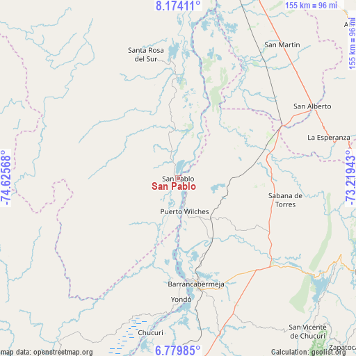
San Pablo GPS coordinates[2]
7° 28' 39.144" North, 73° 55' 21.18" West
| Map corner | latitude | longitude |
|---|---|---|
| Upper-left | 8.17411°, | -74.62568° |
| Center: | 7.47754°, | -73.92255° |
| Lower-right: | 6.77985°, | -73.21943° |
| Map W x H: | 155×155 km | = 96.3×96.3mi |
| max Lat: | 13.38166° ⇑22.1% North |
| San Pablo: | 7.47754° |
| min Lat: | ⇓77.9% South -4.21528° |
| min Long | San Pablo | max Long |
| -81.70636° | -73.92255° | -67.06996° |
| W 66.8%⇐ | ⇒33.2% E |
Elevation
Elevation of San Pablo is 63 m = 207 ft, and this is 1086.3 m = 3564 ft below average elevation for this country.
| Max E: |
3342 m = 10965 ft | 84.7% |
| Avg. | 1149.3 m = 3771 ft | |
| San Pablo | 63 m = 207 ft | |
Min E: |
1 m = 3 ft | 15.3% |
See also: Colombia elevation on elevation.city.
Geographical zone
San Pablo is located in North Torrid zone (between Equator and Tropic of Cancer). Distance of Equator is 831.4 km =516.6 mi to South.| Distance of | km | miles | from San Pablo |
|---|---|---|---|
| North Pole | 9175.6 | 5701.5 | to North |
| Arctic Circle | 6569.7 | 4082.2 | to North |
| Tropic Cancer | 1774.5 | 1102.6 | to North |
| Equator | 831.4 | 516.6 | to South |


Nearby cities:
15 places around San Pablo: (largest is in red/bold)
• Barrancabermeja
46.4 km =28.8 mi,  170°
170°
• Cantagallo
11 km =6.8 mi,  175°
175°
• El Playón
79.3 km =49.3 mi,  90°
90°
• La Esperanza
68 km =42.3 mi,  74°
74°
• Lebrija
87.7 km =54.5 mi,  117°
117°
• Morales
88.9 km =55.2 mi,  3°
3°
• Puerto Wilches
14.7 km =9.1 mi, 168°
• Rionegro
88.4 km =54.9 mi,  105°
105°
• Sabana de Torres
48 km =29.8 mi,  101°
101°
• San Alberto
66.4 km =41.3 mi,  61°
61°
• San Martín
73.8 km =45.9 mi,  37°
37°
• San Vicente de Chucurí
87.2 km =54.2 mi,  139°
139°
• Santa Rosa del Sur
56.1 km =34.9 mi,  344°
344°
• Simití
53.5 km =33.2 mi,  357°
357°
• Yondó
52.4 km =32.6 mi, 178°
Sources, notices
• [Note1] Compared only with cities in Colombia existing in our database
• [Src1] Map data: © OpenStreetMap contributors (CC-BY-SA)
• [Src2] Other city data from geonames.org with taken over terms of usage.
• [Src3] Geographical zone / Annual Mean Temperature by Robert A. Rohde @ Wikipedia
