Santa Rosa del Sur geodata
Santa Rosa del Sur (Bolívar) is a seat of a second-order administrative division; located in Colombia in America/Bogota (GMT-5) time zone. With population of 8,904 people, there are 345 cities with bigger population in this country. Compared to other cities in Colombia, 80.6% of cities are located further ↓South; 63.9% of cities are located further ←West and 61.6% of cities have higher elevation than Santa Rosa del Sur. Note1


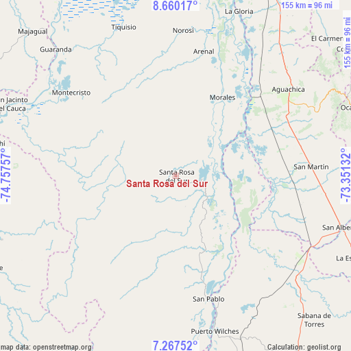
Santa Rosa del Sur GPS coordinates[2]
7° 57' 51.984" North, 74° 3' 15.984" West
| Map corner | latitude | longitude |
|---|---|---|
| Upper-left | 8.66017°, | -74.75757° |
| Center: | 7.96444°, | -74.05444° |
| Lower-right: | 7.26752°, | -73.35132° |
| Map W x H: | 154.8×154.9 km | = 96.2×96.3mi |
| max Lat: | 13.38166° ⇑19.4% North |
| Santa Rosa del Sur: | 7.96444° |
| min Lat: | ⇓80.6% South -4.21528° |
| min Long | Santa Rosa del | max Long |
| -81.70636° | -74.05444° | -67.06996° |
| W 63.9%⇐ | ⇒36.1% E |
Elevation
Elevation of Santa Rosa del Sur is 628 m = 2060 ft, and this is 521.3 m = 1710 ft below average elevation for this country.
| Max E: |
3342 m = 10965 ft | 61.6% |
| Avg. | 1149.3 m = 3771 ft | |
| Santa Rosa del Sur | 628 m = 2060 ft | |
Min E: |
1 m = 3 ft | 38.4% |
See also: Colombia elevation on elevation.city.
Geographical zone
Santa Rosa del Sur is located in North Torrid zone (between Equator and Tropic of Cancer). Distance of Equator is 885.6 km =550.3 mi to South.| Distance of | km | miles | from Santa Rosa del Sur |
|---|---|---|---|
| North Pole | 9121.5 | 5667.8 | to North |
| Arctic Circle | 6515.6 | 4048.6 | to North |
| Tropic Cancer | 1720.4 | 1069 | to North |
| Equator | 885.6 | 550.3 | to South |


Nearby cities:
15 places around Santa Rosa del Sur: (largest is in red/bold)
• Aguachica
61.5 km =38.2 mi,  51°
51°
• Arenal
56.4 km =35 mi,  12°
12°
• Cantagallo
66.8 km =41.5 mi,  166°
166°
• Gamarra
52.6 km =32.7 mi,  40°
40°
• Guaranda
77.1 km =47.9 mi,  316°
316°
• Montecristo
59.1 km =36.7 mi,  308°
308°
• Morales
40.1 km =24.9 mi,  30°
30°
• Norosí
62.6 km =38.9 mi,  1°
1°
• Puerto Wilches
70.7 km =43.9 mi, 165°
• Río Viejo
73.2 km =45.5 mi,  18°
18°
• San Alberto
76.4 km =47.5 mi,  107°
107°
• San Martín
60 km =37.3 mi,  86°
86°
• San Pablo
56.1 km =34.9 mi,  164°
164°
• Simití
12.2 km =7.6 mi, 93°
• Tiquisio
69.8 km =43.4 mi,  340°
340°
Sources, notices
• [Note1] Compared only with cities in Colombia existing in our database
• [Src1] Map data: © OpenStreetMap contributors (CC-BY-SA)
• [Src2] Other city data from geonames.org with taken over terms of usage.
• [Src3] Geographical zone / Annual Mean Temperature by Robert A. Rohde @ Wikipedia
